< 760 to 779 | Home | 800 to 809 >
|
|
|
| ROUTE LOG |
US 278: 0 - 0 US 78: 3.6 - 3.6
|
Creation: Opened as new state route in 1940. Originally ran from SC 28 Beech Island east to US 78 near White Pond, a distance of 27 miles.
| Adjustments: In 1953, SC 781 was truncated to its current routing, replaced by a rerouted SC 28 (now US 278). Improvements: Improved in 1942; Fully paved by 1948. No multilane sections. Comment: SC 781 is a connector that allows US 78 traffic towards Augusta to avoid Aiken altogether. Briefly in the early 50's, SC 781 passed through the new Savannah River Plant. 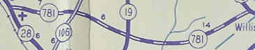
|
|||||
| SC 782 not currently assigned | |||
| Previous SC 782's: |
SC 782: Appeared in 1941 or 1942 as new primary routing. Ran from SC 70 at the Ghents Branch Bridge (Bamberg County) and went north to US 78, then jogged east briefly before heading north to end at SC 517 (current S-5-29/49 jct).
The 5 miles of SC 782 were downgraded to S-5-33 and S-5-34 in 1948. |  |
|
| SC 783 not currently assigned | |||
| Previous SC 783's: |
SC 783: Appeared in 1941 or 1942 as new primary routing. Ran from SC 64 (current US 17 ALT) Cottageville northeast to Givhans Ferry State Park, then wound its way north to US 78 Dorchester, a rather lengthy 20 miles. Included were brief multiplexes with SC 65 (current SC 61) and SC 173 (current S-18-19)
In 1948, SC 783 was downgraded to S-15-35, S-18-30, S-18-19, and S-18-25. The SC 65 piece remained SC 65. | 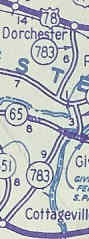 |
|
| SC 784 not currently assigned | |||
| Previous SC 784's: |
SC 784: Appeared in 1941 or 1942 as new primary routing. Ran from SC 204 (current S-18-18) Reevesville in an 8 mile southern loop back around to US 78 St. George.
In 1948, SC 784 was downgraded to S-18-16 and S-18-26. | 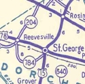 |
|
| SC 785 not currently assigned | |||
| Previous SC 785's: |
SC 785: Appeared in 1941 or 1942 as new primary routing, although this had partly been a piece of SC 381 in the early 30's. Ran from SC 381 (current S-34-50) west of Blenheim south to Argyle, then looped around back north to end at SC 382 (current S-34-18) near Drake. This totaled 6 miles.
In 1948, SC 785 was downgraded to S-34-57 and S-34-35. | 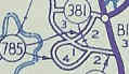 |
|
| SC 786 not currently assigned | |||
| Previous SC 786's: |
SC 786: Appeared in 1941 or 1942 as new primary routing. Ran from US 17-701 to SC 716 (current S-22-18) at Belle Isle Gardens.
The 3 miles of SC 786 were downgraded to S-22-23 in 1948. | 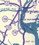 |
|
| SC 790 not currently assigned | |||
| Previous SC 790's: |
SC 790: Appeared in 1941 or 1942 as new primary routing. Ran from US 178 at the Pickens-Anderson County Line north 5 miles to SC 13 (current SC 93) Liberty.
In 1948, SC 790 was downgraded to S-39-27. | 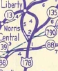 |
|
| SC 791 not currently assigned | |||
| Previous SC 791's: |
SC 791: Appeared in 1941 or 1942 as new primary routing. Ran from SC 384 Adamsville Crossroads(current S-34-17) to SC 79 just south of the North Carolina border, a distance of 5 miles.
In 1948, SC 791 was downgraded to S-34-28. |  |
|
Last update: 25 December 2004
Previous: SC 760 - 779 |
Next: SC 800 - 809
Top | South Carolina Hwy Index
Home