< 60 to 69| Home | 80 to 89>
ROUTE LOG | US 278, SC 64: 0 - 0 SC 3: 0.4 - 0.4 SC 304: 6.9 - 7.3 Bamberg-Barnwell Line: 2.1 - 9.4 US 321 SB: 5 - 14.4 US 78: 0.3 - 14.7 US 321 NB: 0.4 - 15.1 Orangeburg-Bamberg Line: 4.8 - 19.9 SC 332: 2.7 - 22.6 US 301, US 601: 7.1 - 29.7 Creation: Appeared in 1937 or 1938 as new routing. Originally ran from SC 64 Barnwell east to SC 6 (current US 321) Denmark. | Adjustments: In 1940, SC 70 was extended in both directions: east as new routing to SC 332; also west along SC 64 to near the Salkehatchie River, then southwest as new routing 5 miles. In 1941 or 1942, SC 70 was extended southwest again, as more new routing down to SC 28 (current SC 125), along SC 28 to Martin, then southeast as new routing to end at SC 631 (current SC 3). This was SC 70's heydey at 42 miles. In 1948, SC 70 was reduced to run only from SC 64 barnwell to SC 5 (current US 321) Denmark. Also, the 4 mile piece between Martin and SC 37 (current SC 3) remained. SC 70 east of Denmark became secondary routing. SC 70 west of Barnwell became S-6-20 and S-3-45. In 1951 or 1952, the SC 70 piece between Martin and today's SC 3 was downgraded to S-3-47. I believe this is the only piece of primary route to survive the mass denumbering to then later get the ax. In 1957 or 1958, SC 70 was re-extended east from Denmark to its current end at US 301-601. Improvements: SC 70 from Barnwell to Denmark was paved in 1939. In 1941 or 1942, SC 70 was paved on its SC 28 multiplex. SC 70 wasn't paved east of Denmark until it was re-extended east. The discontinuous piece below Martin was never paved before it was downgraded. No multilane sections shown on 2005 Official Map. Comment: SC 70 serves as a direct route from the Orangeburg area to Barnwell. I drove this in 1989 and remember zero about it. | |||||||||||||||||||||||||
ROUTE LOG | SC 81: 0 - 0 SC 284: 2.2 - 2.2 SC 28: 11.3 - 13.5 Creation: Created in 1925 or 1926, running from SC 7-20 (current SC 203) Abbeville west to the town of Lowndesville, a distance of about 16 miles. | Adjustments: In 1927, SC 71 west was truncated to its current ending, when SC 82 (current SC 81) was designated in the area. SC 71 east was probably truncated to SC 28 (now old SC 28) west of Abbeville by 1950. By the mid-80's, SC 71 east was truncated to the SC 28 Bypass. There was no SC 28 Business when I traveled the area in 1987-88, but Official Maps imply there always has been a 28 business. Improvements: Fully paved in 1939. No multilane segments shown on Official Maps. Comment: SC 71 is mostly a local road connecting Abbeville County's west side to the county seat. | |||||||||||||||||||||||||
ROUTE LOG | US 21, SC 5, SC 121 NB: 0 - 0 SC 72 Bus, SC 901: 2.2 - 2.2 SC 324: 4.2 - 6.4 Chester-York Line: 3.1 - 9.5 SC 909 WB: 3.6 - 13.1 SC 909 EB: 0.1 - 13.2 SC 72 Bus, SC 97 NB, SC 121 Bus: 5.4 - 18.6 SC 9 EB, SC 9 Bus: 1 - 19.6 US 321 SB, US 321 Bus, SC 97 SB: 1.3 - 20.9 US 321 NB, SC 9 WB, SC 72 Bus, SC 121 Bus: 1.9 - 22.8 SC 215 SB: 12.6 - 35.4 Union-Chester Line: 1.2 - 36.6 SC 215 NB: 2.7 - 39.6 US 176 WB: 9.2 - 48.8 Newberry-Union Line: 1 - 49.8 US 176 EB, SC 121 SB: 0.5 - 50.3 SC 66: 0.3 - 50.6 Laurens-Newberry Line: 3.1 - 53.7 I-26 (exit 54): 12.2 - 65.9 SC 56 NB, SC 72 Bus: 1.3 - 67.2 US 76: 1.7 - 68.9 SC 56 SB, SC 56 Bus: 1.2 - 70.1 SC 72 Bus: 0.3 - 70.4 SC 39: 11.8 - 82.2 US 221 NB: 4.3 - 86.5 Greenwood-Laurens Line: 0.8 - 87.3 SC 246: 2.5 - 89.8 US 25 SB, US 178 EB, US 221 SB, SC 72 Bus: 5 - 94.8 SC 254: 1.6 - 96.4 US 25 NB, US 25 Bus, US 178 WB, US 178 Bus: 0.6 - 97 SC 72 Bus: 2.6 - 99.6 Abbeville-Greenwood Line: 1.6 - 101.2 SC 203: 7.8 - 109 SC 28: 2 - 111 SC 823: 1.4 - 112.5 SC 81: 11.2 - 123.7 GA STATE LINE: 3 - 126.7 Creation: Created in 1942 as a renumbering of SC 7. Originally ran from US 21 (current US 321 Bus-SC 72 Bus jct) Chester southwest through Whitmire, Laurens, Greenwood, Abbeville, and Calhoun Falls before heading into Georgia. This is the 3rd SC 72. | Adjustments: In 1950, SC 72 was extended northeast to end at US 21-SC 5 east of Rock Hill. This replaced part of US 21 (and had also been part of original SC 7). In 1951 or 1952, SC 72 was straightened out west of Greenwood, replacing SC 702. The old path became S-1-3 and S-24-1. In 1954, SC 72 received its southern bypass of Chester, leaving behind SC 72 Business. Also, SC 72 was straightened out in eastern Abbeville County, plus sent around the south of the town of Abbeville. This left behind S-1-133 east of Abbeville, and SC 28 west of Abbeville (S-1-1 today). The 1959 Official Map shows SC 72 Bypass around the north of Greenwood as Under Construction, and it was open by 1961. This left behind SC 72 Business. Sometime after 1990, SC 72 was placed on a bypass south around Clinton, leaving behind SC 72 Business. The full Clinton bypass was actually built by 1985, but it was P-3002 at first. Official maps do not differentiate when it changed from a P route to SC 56-72 Bypass. Improvements: Fully paved upon designation. SC 72's first 4-lane segment arrived between 1962-64, along the US 176 multiplex. A mile or so east of the Greenwood bypass was 4-laned between 1965-67. The Chester Bypass was 4-laned in 1977. The entire US 221 multiplex was 4-laned between 1983-85. The eastern half of SC 72's Greenwood Bypass was 4-laned by 1987. The easternmost 3 miles of SC 72 were 4-laned in 1989 or 1990. The western half of the Greenwood Bypass was 4-laned in 1992, as was SC 72 from Abbeville east to the Sumter National Forest boundary. All of SC 72 between Abbeville and Greenwood was 4-laned in 1997. SC 72 was 4-laned from Abbeville west to the Georgia State Line in 2005. Comment: SC 72 is a major east-west routing in South Carolina, connecting several larger towns. SC 72 crosses large portions of Sumter National Forest. SC 72's multiplex with SC 121 is easily South Carolina's longest current multiplex at 50 miles. | Previous SC 72's: | SC 72 #1: Created in 1925 or 1926 as new primary routing. Ran from SC 7 (current SC 72) at the Saluda River north to SC 10 (current US 221/S-30-29 jct) Waterloo. In 1932, this SC 72 became part of US 221. SC 72 #2: Appeared in 1940 as new primary routing. Ran as a 2 mile stub north off SC 7 (current SC 72-121) to Leeds in southwestern Chester County. This SC 72 was renumbered as SC 722 in 1942. Today it is S-12-25. | |||||||||||||||||||||||
ROUTE LOG | SC 72, SC 121, SC 901 SB: 0 - 0 SC 901 NB: 0.2 - 0.2 SC 122: 1.7 - 1.9 US 21 Bus, SC 5: 0.1 - 2 Creation: Appeared in 1950. This was never mainline SC 72, but was mainline US 21 in 1949. | Adjustments: None Improvements: The uppermost 3/4 mile was 4-laned in 1974 or 1975. Comment: SC 72 Business was the route of original SC 7. SC 72 Business follows Saluda St. in Rock Hill. | |||||||||||||||||||||||||
ROUTE LOG | US 321, SC 9, SC 72, SC 72 Bus BEGIN, SC 121: 0 - 0 US 321 Bus, SC 9 Bus WB: 1.2 - 1.2 SC 9 Bus EB: 0.1 - 1.3 SC 72, SC 72 Bus END, SC 97, SC 121: 1.8 - 3.1 Creation: Appeared in 1954. This had been mainline SC 72. | Adjustments: None Improvements: No multilane segments shown on 2005 Official Map. Comment: SC 72 Business is multiplexed in its entirety with SC 121 Business, using West End St and Saluda Rd. SC 72 Business was the route of original SC 7, as well as US 21's original routing northeast of downtown Chester. | |||||||||||||||||||||||||
ROUTE LOG | SC 72: 0 - 0 SC 225: 1.4 - 1.4 US 25 Bus, US 178 Bus: 1.5 - 2.9 SC 34: 0.2 - 3.1 SC 254: 0.3 - 3.4 US 25, US 178, US 221, SC 72: 1 - 4.4 Creation: Appeared in 1960 or 1961. This was previously mainline SC 72. | Adjustments: None Improvements: No multilane segments shown on 2005 Official Map. Comment: SC 72 Business uses Cambridge and Reynolds Sts through Greenwood. SC 72 Business was the route of original SC 7. | |||||||||||||||||||||||||
| I-73 |
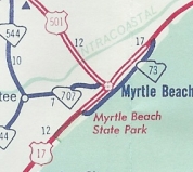
ROUTE LOG | US 17 Bus: 0 - 0 US 17 Bus: 9.8 - 9.8 Creation: Created in 1960, running as it does now, but ending a little further north at the end of N. Ocean Blvd. I don't believe this had ever been primary routing before. This is the 5th SC 73. | Adjustments: Between 1998-2000, the northern end of SC 73 was adjusted slightly, to cut west to US 17 Bus at 79th St.
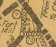
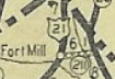
Improvements: Fully paved upon designation. SC 73 was made 4-lane for all but the northernmost mile or so between 1998-2000. Comment: SC 73 runs right along Ocean Blvd, right along the waterfront in Myrtle Beach. SC 73 is the "cruising" drag for the beach crowd, which I've done a time or two, though not in at least 15 years. SC 73 is the only route number to be used more than 3 times as a state route. | Previous SC 73's: | SC 73 #1: Created around 1926 as new primary routing. Ran from SC 7 (current US 21 Bus) Fort Mill east to SC 26 (current US 521). In 1928 this became SC 211. Today it is part of SC 160.
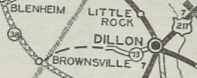
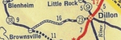
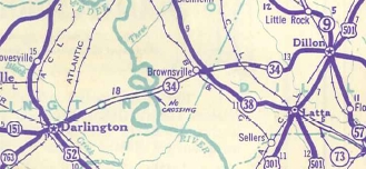
SC 73 #2: Created by 1931 as new primary routing. Ran from US 217-SC 9 (current US 301-501, SC 9-57) Dillon west about 6 miles. In 1937, SC 73 was extended west to SC 38 Brownsville. In 1939, SC 73 was renumbered as SC 34.
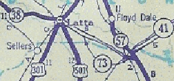
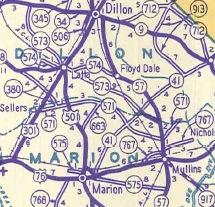
SC 73 #3: Appeared in 1939 as new primary routing. Ran from US 301-501 Latta southeast to SC 57 (current SC 41). There was a break in the middle of this routing. In 1940, SC 73 was made continuous between Latta and SC 57, a distance of 12 miles. In 1942, SC 73 was renumbered as part of SC 573. Today it is part of SC 917.
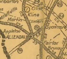
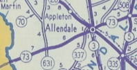
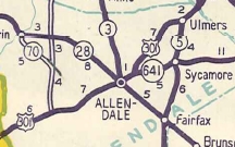
SC 73 #4: Appeared in 1942 as a renumbering of the first SC 331 to match GA 73. Ran from SC 5-641 (current US 321-SC 641 jct) Sycamore west through Allendale to the Georgia State Line. In 1947 or 1948, SC 73 became US 301 from the state line to Allendale and SC 641 from Allendale to Sycamore.
| |||||||||||||||||||||||

| I-74 |
| SC 74 not currently assigned | ||||||||||||||||
| Previous SC 74's: | SC 74 is the lowest number for which I have not found a primary routing. Perhaps it was a 2-block route somewhere. Maybe they'll build an outer Charlotte Beltway and route US 74 over it. Then SC can have a primary 74...or maybe I-74 will actually be signed someday. | |||||||||||||||
ROUTE LOG | SC 5: 0 - 0 US 521 SB: 3.1 - 3.1 US 521 NB: 3.4 - 6.5 NC STATE LINE: 1.9 - 8.4 Creation: Created in 1937 as a renumbering of SC 12 #2. Originally ran only from US 521 Hancock east to the state line | Adjustments:Between 1960-64, SC 75 was extended to SC 5 Van Wyck, replacing part of SC 504. Improvements: SC 75 was fully paved upon inception. SC 75 was 4-laned with the US 521 multiplex between 1983-85. Comment: SC 75 serves Andrew Jackson State Park. There is a SC 75 TRUCK that follows SC 5 to US 521, presumably to avoid Van Wyck. | ||||||||||||||

| US 76 |
| I-77 |
| SC 77 not currently assigned | ||||||||||||||||
| Previous SC 77's: | SC 77 #1: Appeared in 1937 as a renumbering of SC 98 #1, running from SC 9 Hickson. In 1940, SC 77 south was truncated about a mile to the modern location of SC 9 leaving behind Delta PLant Road. About 1960, SC 77 was renumbered as SC 177. SC 77 #2: Appeared on South Carolina official maps in at least 1981 and 1982, as proposed segments of today's I-77 north of US 76-378 and south of I-20 (dotted lines did not connect). The dotted lines west of US 76-378 on those same maps still showed I-326. When the segments labeled as SC 77 were actually opened years later, they were first signed as I-77. | |||||||||||||||
| US 78 |
ROUTE LOG | SC 9: 0 - 0 SC 38: 4 - 4 SC 385: 3.7 - 7.7 NC STATE LINE: 1.6 - 9.3 Creation: Appeared as a renumbering of part of SC 38 in 1938. Originally ran from the state line where it crosses now, but ran south to US 15 (current Main St) Bennettsville. This is the 2nd SC 79. | Adjustments: Between 1968-70, SC 79 was rerouted to run due west to SC 9, replacing all of SC 383. The old route south to Bennettsville became SC 385. Improvements: SC 79 was paved upon inception. No multilane segments appear on the 2005 Official Map. Comment: SC 79 serves as a direct way to switch from SC 9 to US 74. Passes through no towns in South Carolina. | Previous SC 79's: | SC 79 #1: Created about 1937 as new primary routing. Ran from US 78 Denmark southeast about 2 miles. In 1938, SC 79 was renumbered as SC 68. Today it is S-5-12. |  | |||||||||||
Last Update: 25 October 2007
Previous: SC 60 - 69 | Next: SC 80 - 89
Top | South Carolina Hwy IndexHome