< 50 to 59 | Home | 70 to 79 >
|
|
|
| ROUTE LOG |
SC 6: 0 - 0 Richland-Lexington Line: 3.5 - 3.5 I-26 (exit 102), US 76: 0.5 - 4 US 176: 1.3 - 5.3
|
Creation: Appeared about 1929 as new routing. Ran is it does today, although its eastern endpoint was US 76/SC 2 then.
| Adjustments: None Improvements: Paved upon inception. Between 1998-2000, SC 60 is shown as multilane between Irmo and I-26. Comment: SC 60 serves Irmo. SC 60 only had a partial interchange with I-26 until the 1990s. I thought I saw a 1941 Topo Map when I attended Clemson in the late 80s showing SC 60 multiplexed with SC 6 to Lexington, but I have not found any evidence of that in recent times. |
|||||||||
|
|
|
| ROUTE LOG |
US 78: 0 - 0 US 21: 6.6 - 6.6 Colleton-Bamberg Line: 0 - 6.6 SC 217: 7.1 - 13.7 I-95 (exit 68): 3.6 - 17.3 US 15: 2.8 - 20.1 SC 651: 7.1 - 27.2 Dorchester-Colleton Line: 6.8 - 34 SC 27: 3.5 - 37.5 US 17 ALT SB: 5 - 42.5 US 17 ALT NB: 0.3 - 42.8 SC 165: 4.6 - 47.4 Charleston-Dorchester Line: 5.5 - 52.9 SC 7: 10 - 62.9 SC 171 NB: 1.5 - 64.4 SC 171 SB: 1.6 - 66 US 17: 0.3 - 66.3 SC 30: 1 - 67.3
|
Creation: Created in 1923, running from SC 6(current US 17 jct with S-10-6) west of Charleston to Summerville, ending at SC 2 (current S-18-65).
| Adjustments: In 1936, SC 61 was extended north out Richardson Ave to US 78/SC 2 (which moved out of Summerville by 1931). About 1937, SC 61 was extended south onto James Island, then west onto Johns Island to about today's S-10-54. In 1939, SC 61 was extended southwest all the way to Rockville. In 1940, SC 61 south of US 17 on James and Johns Islands were renumbered as SC 700 (today this is still mostly SC 700 with a tiny piece of SC 171 on Wesley Dr) The 1948 Official Map shows SC 61 using Wappoo Rd (current S-10-26) to get to US 17 instead of Magnolia Dr (current S-10-6), which became part of SC 614. The 1949 and 1950 Official Maps show SC 61 on its current St. Andrews Blvd alignment which the main side of those maps continue to show that as SC 614. In 1951 or 1952, SC 61 was rerouted away from Summerville and out to Bamberg County as it does now. This replaced all of SC 650 and most of SC 65. The old route into Summerville became part of SC 165 (today this is SC 165, a little US 17 ALT, and S-18-65). SC 61 was extended south from US 17 to SC 30 as new construction in 1997. Improvements: Fully paved in all alignments since about 1928. SC 61 was multilaned from SC 171 NB split to US 17 between 1960-62. The first official map to show SC 61 4-laned from SC 171 to SC 7 was between 1986-88, but I know it was 4-laned by the late 70s. SC 61 was 4-laned from SC 7 north to the SC 61 CONN to the Mark Clark Expwy about 1987. SC 61 was 4-laned when built between US 17 and SC 30 in 1997. Comment: SC 61 serves as an alternate to US 78, with fewer towns. In advance of the US 78-SC 61 split there is a mileage sign to Charleston for both routes. From SC 7 to SC 165, SC 61 is a state scenic route, as it passes by historic plantations (Magnolia, Middleton, Drayton Hall). The road has a canopy of live oaks over this stretch. However, Hurricane Hugo and some development on the southern end of this has lessened its beauty over the years. SC 61 is technically blown off by I-526, but a 4-lane connector was built in the mid 1980s to connect them. This connector is now part of the "SC 61 Expressway" which extends out to Bees Ferry Road and was intended to eventually connect back up with SC 61 somewhere further north. |
|||||||||
| SC 62 not currently assigned | ||||||||||||||||
| Previous SC 62's: |
SC 62 #1 Appeared in 1923, running from SC 6 (current US 17) Red Top over to SC 61 Drayton Hall, about 5 miles. SC 62 was downgraded to secondary status in 1937 or 1938, and today is S-10-57 Bees Ferry Road. This route was one of the first primary routes to be permanently downgraded.
SC 62 #2:Appeared as new routing in 1940, running from US 76/SC 2 (current US 176) Irmo south to the Richland-Lexington Line at St. Andrews near Columbia, for a length of 8 miles. In 1948, SC 62 was downgraded to S-40-27, S-32-42, and S-32-36. |
|||||||||||||||
|
|
|
| ROUTE LOG |
US 278: 0 - 0 SC 363: 2.9 - 2.9 Colleton-Hampton Line: 3.8 - 6.7 US 21: 8.8 - 15.5 I-95 (exit 53): 8 - 23.5 US 17 ALT SB: 1.9 - 25.4 SC 303: 1.5 - 26.9 US 15, US 17 ALT NB: 0.3 - 27.2 SC 64 Bus: 1 - 28.2
|
Creation: Created in 1925 or 1926 as new routing. Originally ran from SC 1 (current US 278) Hampton to SC 30 (current US 17 ALT) Walterboro.
| Adjustments:Around 1931 or so, SC 63 was rerouted to end at Varnville instead of Hampton, leaving behind a secondary road that eventually became SC 363. In 1951 or 1952, SC 63 was extended east to SC 64 (now Bus SC 64), replacing a piece of US 17. Improvements: SC 63 was fully paved in 1939. SC 63 was 4-laned east of I-95 in 1979. Comment: SC 63 serves as the main way to get from I-95 NB to Walterboro. Otherwise, SC 63 is a sleepy ride through some empty spaces. |
|||||||||
|
|
|
| ROUTE LOG |
US 17: 0 - 0 SC 64 Bus: 14.2 - 14.2 US 17 ALT: 0.8 - 15 US 15: 2.8 - 17.8 SC 64 Bus: 0.7 - 18.5 I-95 (exit 57): 0.8 - 19.3 US 21: 10.1 - 29.4 SC 212: 0.6 - 30 SC 641: 6 - 36 SC 217: 2.7 - 38.7 Bamberg-Colleton Line: 1.7 - 40.4 US 601: 2.3 - 42.7 US 301 SB: 9.3 - 52 US 301 NB: 0.3 - 52.3 US 321: 2.4 - 54.7 Barnwell-Bamberg Line: 2.3 - 57 SC 3: 9.1 - 66.1 US 278 EB: 0.5 - 66.6 SC 70: 0.3 - 66.9 US 278 WB: 0.3 - 67.2 Savannah River Site Line: 6 - 73.2
|
Creation: Appeared in 1925 or 1926 as new routing. Originally ran from SC 28 (current SC 125) near Ellenton to SC 6-SC 301 (current US 21-SC 64 jct) near Ruffin.
| Adjustments: In 1928, SC 64 was extended east to US 17 (current US 17 ALT) Walterboro, replacing part of SC 6. Around 1930, SC 64 was extended east as new routing to US 78-SC 2 Summerville By 1932, SC 64 was extended east, ending at US 17 (current US 52) Moncks Corner. In 1950, SC 64 was extended in both directions: west as a multiplex with SC 28 to SC 781 (current US 278) Beech Island; east replacing SC 179 to Jamestown, north with SC 511 (current SC 41) for 7 miles, then east to end at US 521 Sampit, replacing SC 528. This brought SC 64 to its longest routing - 181 miles. In 1951 or 1952, SC 64 was rerouted east of Walterboro to instead head southeast to US 17 Jacksonboro - this replaced what had been part of US 17. The road to Summerville, Moncks Corner, Jamestown, and Sampit became part of US 17 ALT. Also in this timeframe, the Savannah River Plant was created. The 1952 Shell map shows SC 64 within the plant boundaries to be gone (SRS route B was SC 64's route), but there remained a SC 28-64 multiplex from the boundary near Jackson over to Beech Island. In 1953, the SC 64 piece from Jackson to Beech Island was renumbered as SC 125. Between 1983-85, the Walterboro Bypass was built. It was first signed as P-1501, but sometime in the mid to late 80s became SC 64 Bypass. Improvements: By 1932, SC 64 was paved from Earhardt to Walterboro. In 1933, SC 64 was paved from Ellenton to Barnwell and from Summerville to US 78. In 1934, SC 64 was paved most of the way from Barnwell to Olar. In 1935, SC 64 was partially paved west of Moncks Corner. In 1936, SC 64 was paved completely to Olar, and more of Berkeley County. In 1937 or 1938, SC 64 was paved from Walterboro to Moncks Corner. In 1939, the last section of SC 64 to be paved was completed between Olar and Ehrhardt. SC 64 was 4-laned from Barnwell west to the Savannah River Plant between 1953-55. In 1973, SC 64 was 4-laned on its US 301 multiplex. In 1976, SC 64 was 4-laned from I-95 to Walterboro. When SC 64 was moved onto the Walterboro bypass, it was 4-laned. Comment: SC 64 serves as a decent alternative from Charleston (via US 17) to the Augusta, GA area (via SC 641 and SC 125). |
|||||||||
|
|
|
| ROUTE LOG |
SC 64: 0 - 0 SC 63: 0.1 - 0.1 US 17 ALT NB: 0.5 - 0.6 US 17 ALT SB: 0.6 - 1.2 US 15 SB: 0.3 - 1.5 US 15 NB: 0.2 - 1.7 SC 64: 0.6 - 2.3
|
Creation: Appeared in the mid 1980s. This had been mainline SC 64.
| Adjustments: None Improvements: SC 64 Business west from the US 15 SB split was 4-laned upon inception. Comment: SC 64 Business has brief multiplexes with US 15 and US 17 ALT. SC 64 Business was the route of original SC 6. Uses Bells Hwy, N. Jeffries Blvd, Paul St, Wichman St, Padgett Loop, and Hampton St. |
|||||||||
|
|
|
| ROUTE LOG |
US 17: 0 - 0 SC 9: 4.7 - 4.7
|
Creation: Appeared in 1980 or 1981 as a renumbering of SC 69. Originally ran like today, but also cut back west to US 17 at its Intracoastal Waterway Bridge. This is the 2nd SC 65.
| Adjustments: SC 65 was truncated to Cherry Grove Beach in 1987 or 1988, replaced by an extended SC 9. Improvements: Fully paved upon inception; no multilane sections shown on the 2005 Official Map. Comment: SC 65 runs along the oceanfront, using 23rd Av to get from US 17 to the beach. | Previous SC 65's: |
SC 65 #1: Created about 1930 as new primary routing. Ran from US 78 at the Edisto River bridge south and east to SC 61 (current SC 165-642 jct) south of Summerville.
In 1933, this SC 65 was rerouted slightly at its western end to more direct line to US 78. The old route from Farrell Crossroads was briefly unnumbered but became SC 121 #2. Today it is S-5-18. The 49 miles of SC 65 were renumbered in 1951 or 1952. Most of it became an extended SC 61, but the easternmost few miles became part of SC 642. |
|||||||
|
|
|
| ROUTE LOG |
SC 56: 0 - 0 US 76: 2.7 - 2.7 I-26 (exit 60): 3.7 - 6.4 Newberry-Laurens Line: 3.7 - 10.1 SC 72: 8.2 - 18.3
|
Creation: Appeared in 1934 as new routing. Ran only from SC 56 to US 76/SC 2 Goldville (now Joanna).
| Adjustments: In 1941 or 1942, a second piece of SC 66 was created, running from SC 706 (current S-36-32) Eisons Crossroads west to the Laurens County Line. In 1948, the gap between US 76 and the county line were closed. Also, SC 66 was extended east over what was SC 706 to Whitmire. Improvements: Fully paved since 1941 or 1942. No mulitlane sections exist. Comment: SC 66 travels through the heart of Sumter National Forest. SC 66 has a turn-filled routing in Whitmire. |
|||||||||
|
|
|
| ROUTE LOG |
US 378: 0 - 0 McCormick-Edgefield Line: 1.2 - 1.2 Greenwood-McCormick Line: 3.4 - 4.6 US 25, US 178: 11.3 - 15.9
|
Creation: Appeared in 1936 as new routing. Ran is it does today, although its southern endpoint was SC 43 then.
| Adjustments: In 1941 or 1942, SC 67 was extended south to SC 23 just west of Edgefield. This brought SC 67 to a length of 30 miles. In 1948, SC 67 south was truncated back to its original (and current) endpoint at SC 43. Improvements: Paved from SC 43 to Callison by 1938. Callison to US 25-178 was paved in 1939. There are no mulitlane segments on SC 67. Comment: SC 67 serves Callison, and is a route I have never driven. |
|||||||||
|
|
|
| ROUTE LOG |
US 278: 0 - 0 I-95 (exit 38): 13.4 - 13.4 US 17 ALT, US 21: 1.6 - 15
|
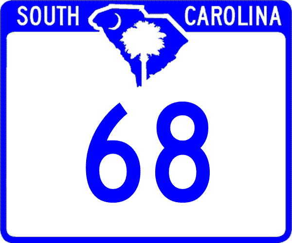
Creation: Appeared about 1967 as a renumbering of part of SC 28. Ran is it does today. This is the 3rd SC 68.
| Adjustments: None Improvements: Paved upon inception. There are no mulitlane segments on SC 68. Comment: SC 68 provides a direct connection from I-95 to the Hampton-Varnville areas. | Previous SC 68's: |
SC 68 #1: Created as new routing in 1937, running from SC 381 near Clio northeast to the NOrth Carolina State Line. In 1938 this was renumbered as SC 83. See scan at right.
SC 68 #2: Created in 1938 as a renumbering of original SC 79. Ran as a 2-mile stub southeast from US 78 Denmark. In 1948, SC 68 was downgraded to S-5-12. It is unclear if SC 68 was extended to SC 33 (current US 301) between 1943-48 before its elimination from the primary system. | 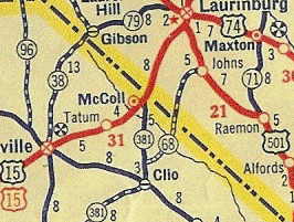 |
||||||
| SC 69 not currently assigned | |||
| Previous SC 69's: |
SC 69 #1 Appeared in 1937 or 1938, running from SC 4 (current S-38-1) Orangeburg northeast to SC 31 (current US 176) Cameron.
SC 69 was replaced by a modern routing of SC 33. Most of SC 69 was actually abandoned. The 1938 Official Map clearly shows it south of the railroad tracks in Orangeburg County. This means SC 69 probably used Myers Rd, S-38-1445, S-38-1863, and several unnumbered dirt roads. SC 69 #2:Appeared in 1939, running from US 178 Pelion east to SC 6 Swansea. This was a renumbering of part of today's SC 45. In 1941 or 1942, SC 69 was rerouted away from Pelion and instead ended at SC 546 (current S-32-45) for a length of 11 miles. In 1948, SC 69 was downgraded to S-32-9 and S-32-55. SC 69 #3:Created as new primary routing in 1977. Ran from US 17 Atlantic Beach up to Cherry Grove Beach, then cut west back to US 17 at its Intracoastal Waterway bridge. The piece cutting back to US 17 was once part of SC 9. SC 69 was renumbered as SC 65 in 1980 or 1981. Today, the part west of Cherry Grove Beach is again part of SC 9. |
||
Last Update: 31 December 2005
Previous: SC 50 - 59 |
Next: SC 70 - 79
Top | South Carolina Hwy Index
Home