< SC 400 | Home SC 402 >
| SC 401 not currently assigned | ||||||
| Previous SC 401's: 1932 ROUTE LOG SC 40: 0 - 0 END SC 401: 7 - 7 1946 ROUTE LOG SC 215: 0 - 0 SC ?: 0.1 - 0.1 SC 22: 6.7 - 6.8 |
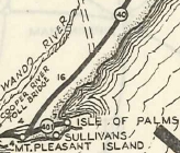
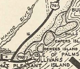
SC 401 #1 Appeared between 1927-29 as new primary routing, running from SC 40 (now SC 703) to Fort Moultrie, Sullivans Island and the Isle of Palms. It is unclear where exactly SC 401 ended but it is likely it was in the vicinity of where SC 517 meets SC 703.
In 1933, SC 401 was renumbered as SC 703. SC 401 used Pitt St/Church St, Hibben St, and Whilden St. On Sullivans Island SC 401 used Osceola Ave and Middle St. On the Isle of Palms, SC 401 used S-10-7 Carolina Ave/4th St/Ocean Blvd/JC Long Blvd.
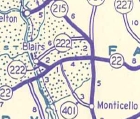
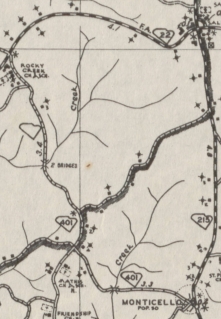
SC 401 #2: Appeared in 1942 as new primary routing, running from SC 215 Monticello west 3.3 miles to today's S-20-99/257 jct. It is likely the first 0.1 mile was part of SC 215 before. In 1946, SC 401 was extended northwest to SC 22 (now SC 34). In 1947, SC 401 was downgraded to S-20-29, S-20-36, and S-20-37. Today most of the 1942 addition is under Monticello Reservoir. East of the water is S-20-11 and west of it is S-20-257 spur and some of S-20-99.
| |||||
Previous: SC 400 |
Next: SC 402
Top | South Carolina Hwy Index
Home
Page last modified 23 May 2015