< SC 330 | Home | SC 331 ALT | SC 332 >
| SC 331 not currently assigned | ||||||
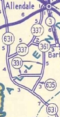
| Previous SC 331's: 1941 ROUTE LOG Georgia State Line: 0 - 0 SC 631: 5.6 - 5.6 SC 337: 6.4 - 12.0 SC 3 SB: 0.7 - 12.7 SC 28: 0.1 - 12.8 SC ?: 0.1 - 12.9 SC 3 NB: 0.3 - 13.2 SC 508: 1.2 - 14.4 SC 5, SC 641: 5.4 - 19.5 1946 ROUTE LOG SC 631: 0 - 0 SC 635: 3.8 - 3.8 SC 361: 4.9 - 8.7 |
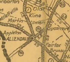
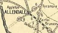
SC 331 #1: Appeared in 1925 or 1926 as new primary routing, running from SC 33 (now US 321) Sycamore southwest through Allendale to the Georgia State Line.
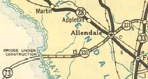
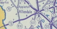
By 1929, official maps showed the last 6 miles (i.e. west of today's SC 3) to the Savannah River as projected road. If SC 331 ever used Old Orangeburg Rd into Sycamore it stopped doing so by 1937. In 1936 or 1937, SC 331 was extended west as new construction to the Savannah River. In 1940, SC 331 was opened across the first bridge crossing (swinging drawbridge) in this area to connect with GA 73. In 1942, SC 331 was renumbered as SC 73. Today it is the very intact (though not driveable) 3 miles of causeway and bridges from the Savannah River (abandoned in 1965) to the divided highway location on US 301; US 301 through Allendale; SC 641 to Sycamore except SC 331 used what is now a 1.5 mile unpaved road west from Kearse Rd (west of Jackson Branch near Sycamore)
SC 331 #2 Appeared in 1942 as new primary routing, running from SC 631 (now SC 3) northeast to SC 361 (now S-3-23) west of Barton.
| |||||
Previous: SC 330 |
Next: SC 331 ALT | SC 332
Top | South Carolina Hwy Index
Home
Page last modified 12 June 2015