< SC 72 | Home | SC 73 ALT | SC 75 >
| SC 73 not currently assigned | ||||||||||||||||
| Previous SC 73's: 1927 ROUTE LOG US 21: 0 - 0 SC 26: 5.3 - 5.3 1938 ROUTE LOG SC 38: 0 - 0 Dillon-Marlboro Line: 1.7 - 1.7 SC 9: 13.5 - 15.2 1941 ROUTE LOG US 301, US 501, SC 38: 0 - 0 Marion-Dillon Line: 9.4 - 9.4 SC 41: 0 - 9.4 SC 57: 2.3 - 11.7 1947 ROUTE LOG Georgia State Line: 0 - 0 SC 631: 5.6 - 5.6 SC 337: 6.4 - 12.0 SC 3 SB: 0.7 - 12.7 SC 28: 0.1 - 12.8 SC ?: 0.1 - 12.9 SC 3 NB: 0.3 - 13.2 SC 508: 1.2 - 14.4 SC 5, SC 641: 5.4 - 19.5 2009 ROUTE LOG US 17 Bus: 0 - 0 US 17 Bus: 9.3 - 9.3 |
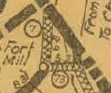
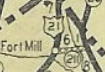
SC 73 #1: Created around 1926 as new primary routing. Ran from SC 7 (current US 21 Bus) Fort Mill east to SC 26 (current US 521).
In 1928 this became SC 211. Today it is part of SC 160.
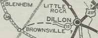
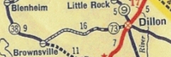
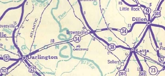
SC 73 #2: Created in 1932 as new primary routing by Act of SC Legislature. Ran from SC 9 (now S-17-96 Martin Luther king Blvd) Dillon west about 6 miles. In May 1936 (SCDOT), SC 73 was extended west as new primary routing to SC 38 Brownsville. In 1939, SC 73 was renumbered as SC 34.
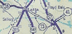
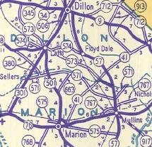
SC 73 #3: Appeared in 1939 as new primary routing. Ran from US 301-501 Latta southeast to SC 57 (current SC 41). There was a break in the middle of this routing. In 1940, SC 73 was made continuous between Latta and SC 57, a distance of 12 miles. In 1942, SC 73 was renumbered as part of SC 573. Today it is part of SC 917 except Railview Rd/Randy Farm Ln just north of today's SC 41 ALT; also SC 573 was rebuilt onto new alignment in the Burke Rd area.
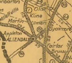
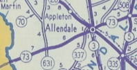
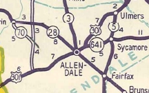
SC 73 #4: Appeared in 1942 as a renumbering of the SC 331 to match GA 73. Ran from SC 5-641 (now US 321-SC 641 jct) Sycamore west through Allendale to the Georgia State Line. In 1947, SC 73 became US 301 from the state line to Allendale and SC 641 from Allendale to Sycamore. Today it is the very intact (though not driveable) 3 miles of causeway and bridges from the Savannah River (abandoned in 1965) to the divided highway location on US 301; US 301 through Allendale; SC 641 to Sycamore except SC 73 used what is now a 1.5 mile unpaved road west from Kearse Rd (west of Jackson Branch near Sycamore)
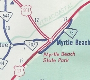
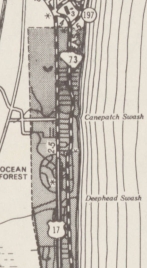
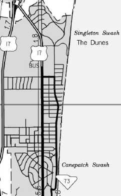
SC 73 #5: Appeared in 1960 as a bit of new construction; upgrades to S-26-83, S-26-28, S-26-69, S-26-53 along Ocean Blvd from US 17 at Myrtle Beach State Park along the Oceanfront back to US 17 at Ocean Forest. Some of this near central Myrtle Beach had been US 17 ALT in the 1940s. Between 1998-2000, the northern end of SC 73 was adjusted slightly, to cut west to US 17 Bus at 79th St. In 2006, SC 73 was completely decommissioned. A small portion north of downtown Myrtle Beach is S-26-80 but 90% of it is just Ocean Blvd. SC 73 is the only state route to have been used more than 3 times.
| |||||||||||||||

Previous: SC 72 |
Next: SC 73 ALT | SC 75
Top | South Carolina Hwy Index
Home
Page last modified 31 October 2015