< 310 to 319 | Home | 330 to 339 >
| SC 320 not currently assigned | ||||||||||||||||
| Previous SC 320's: |
SC 320: Appeared in 1934 as a renumbering of a piece of SC 32. Ran from SC 303 Green Pond east to SC 32 (current US 17), a distance of 1.5 miles, and was fully paved.
In 1948, SC 320 was downgraded to S-15-14. | 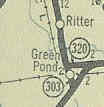 |
||||||||||||||
| US 321 |
| SC 321 not currently assigned | ||||||||||||||||
| Previous SC 321's: |
SC 321: Appeared between 1924-26 as new primary routing. Ran from SC 32 (current S-15-14) Green Pond north to SC 30 (current US 17 ALT-SC 63) Walterboro, a distance of 12 miles.
In 1930, SC 321 was renumbered as SC 303. |
|||||||||||||||
|
|
|
| ROUTE LOG |
SC 49: 0 - 0 US 321 SB: 11.6 - 11.6 US 321 NB: 0.1 - 11.7 SC 324: 6.6 - 17.3 SC 901: 4.9 - 22.2 SC 5: 1 - 23.2 US 21 Bus, SC 274: 1 - 24.2
|
Creation: Created in 1937 or 1938 as new routing. Originally ran only from US 321 McConnellsville to US 21 Rock Hill.
| 
Adjustments: In 1940, SC 322 was extended west to SC 91 (current SC 49) Bullock Creek. 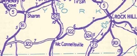
Improvements: SC 381 was fully paved between US 321 and US 21 in 1939 In 1951 or 1952, SC 322 was paved between SC 91 and SC 907 (current SC 97). The remainder of SC 322 was paved between 1954-58 No multilane sections shown on maps Comment: SC 322 serves southwestern York County. |
|||||||||
| SC 323 not currently assigned | ||||||||||||||||
| Previous SC 323's: |
SC 323: Appeared in 1940 as new routing. Ran from SC 32 (current US 17) near the Ashepoo River south to Bennetts Point, 17 miles away.
In 1948, SC 323 was downgraded to S-15-26, which intersects no other roads between its endpoints. | 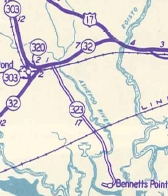 |
||||||||||||||
|
|
|
| ROUTE LOG |
SC 5 Bus: 0 - 0 SC 322: 9 - 9 SC 72, SC 121: 5 - 14
|
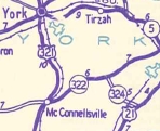
Creation: Created in 1948 mostly as new routing. Originally ran US 321-SC 5 York northwest to SC 55 near Kings Creek. The westernmost 3 miles had been SC 556 prior to 1948. This is the 2nd SC 324.
| Adjustments: In 1950, SC 322 was extended east to its current ending at SC 72 as new routing, although some of this had been part of the 1st SC 324. This gave SC 324 its maximum length of 27 miles. In 1951 or 1952, SC 324 west was truncated to its current end in eastern York, replaced by a rerouted SC 5 (which used to go through Sharon and Hickory Grove on its way to Kings Creek). Improvements: SC 324 was fully paved upon creation; no multilane segments Comment: SC 324 #1 and #2 may have been one and the same, but two different 1946 maps show York to SC 55 as unnumbered... | Previous SC 324's: |
SC 324 #1: Appeared in 1940 as new primary routing. Ran from SC 322 east to US 21 (current SC 72-121) near Ogden.
In 1941 or 1942, SC 324 was extended west to US 321 Delphia. Also, a discontinuous segment of SC 324 appeared as a short stub off SC 5 east of York (today's SC 324's endpoint). 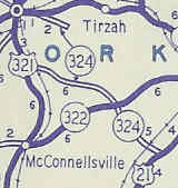
In 1948 the 11 miles of continuous SC 324 were downgraded to S-46-32, and the discontinuous piece was downgraded as well. Today, the stub piece is connected to the original piece, and has been numbered as SC 324 since 1950. |
|||||||
| SC 325 not currently assigned | ||||||||||||||||
| Previous SC 325's: |
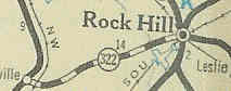
SC 325: Appeared in 1941 or 1942 as new routing. Ran from US 321 Lowrys south to SC 907 (current SC 97) near Chester, a distance of 5 miles.
SC 325 was downgraded to secondary status in 1948, but later became part of today's US 321. | 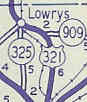 |
||||||||||||||
| I-326 |
| SC 326 not currently assigned | ||||||||||||||||
| Previous SC 326's: |
SC 326: Appeared in 1941 or 1942 as new routing. Ran as a 1 mile stub south off US 17 Jacksonboro.
SC 326 were downgraded to S-15-30 in 1948. |  |
||||||||||||||
|
|
|
| ROUTE LOG |
US 52, US 301: 0 - 0 SC 51 NB: 5.1 - 5.1 SC 51 SB: 0.1 - 5.2 US 76 EB, US 301 NB: 10.6 - 15.8 US 76 WB, US 301 SB: 1.7 - 17.5 I-95 (exit 170): 5.1 - 22.6
|
Creation: Appeared as new primary routing in 1941 or 1942. Ran only from US 52 Effingham to SC 51 Evergreen.
| Adjustments: In 1947 or 1948, SC 327 was extended east as new routing to end at US 76-301 Winona (just west of the Great Pee Dee River). SC 327 was rerouted to run from Claussen to US 76-301 Mars Bluff in 1957 or 1958. The old way to US 76-301 became some of S-21-13 and S-21-24. SC 327 was extended to I-95 in 1971 or 1972 replacing parts of S-21-64. SC 327 was rerouted slightly to avoid the lumber mill near Claussen in the early 90's. When I drove down I-95 in January 2005, SC 327 was posted to continue north, to where I do not know. Improvements: Paved from Effingham to Evergreen in 1951 or 1952; Evergreen to Clausen was paved in 1953; SC 327 was fully paved in 1957 or 1958. SC 327 was multilaned on its US 76-301 multiplex when extended in 1971-72. The piece around Francis Marion College has been 4-laned for a long time, as well. The section from Mars Hill to I-95 was 4-laned in 1992. Comment: SC 327 serves as the main way to get from I-95 to US 76 for the ride to Myrtle Beach. SC 327 did not used to touch US 301 in Effingham, but US 301 was realigned to make the connection in the late 90's. |
|||||||||
| SC 328 not currently assigned | ||||||||||||||||
| Previous SC 328's: |
SC 328: Appeared in 1941 or 1942 as new primary routing. Ran from US 321 York south for 6 miles.
In 1948, SC 328 was downgraded to S-46-35. | 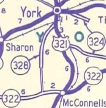 |
||||||||||||||
|
|
|
| ROUTE LOG |
SC 105: 0 - 0 US 29: 4.3 - 4.3 I-85 (exit 96), SC 18: 1.9 - 6.2
|
Creation: Created between 1980-82 as an upgrade to S-11-32. Ran as it does today. The northernmost 2 miles had been SC 180 prior to 1948. This is the 2nd SC 329.
| Adjustments: None Improvements: SC 329 was fully paved upon creation; no multilane segments Comment: SC 329 serves as an eastern bypass for Gaffney, although hardly anyone probably needs to go from SC 105 north to SC 18.... | Previous SC 324's: |
SC 329: Appeared in 1941 or 1942 as new routing. Ran from SC 22 (current SC 34) near Glymphville southeast through Peak to SC 177 (current US 176) in the northwest corner of Richland County, 13 miles away.
In 1948, SC 329 was downgraded to S-36-28 and S-40-32. | 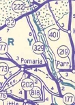 |
||||||
Last Update: 21 March 2005
Previous: SC 310 - 319 |
Next: SC 330 - 339
Top | South Carolina Hwy Index
Home