< SC 266 | Home | SC 268 >
|
|
|
| ROUTE LOG |
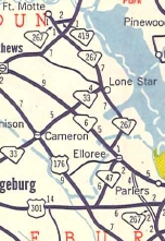
US 15: 0 - 0 US 301: 1.5 - 1.5 SC 6 EB: 3.8 - 5.3 SC 47: 1.9 - 7.2 SC 6 WB: 1.2 - 8.4 Calhoun-Orangeburg Line: 1.3 - 9.7 SC 33: 5.7 - 15.4 SC 419: 3.0 - 18.4 US 601: 4.3 - 22.7
|
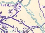
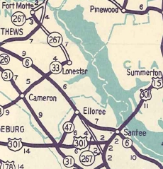
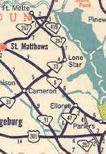
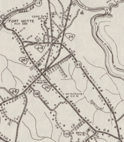
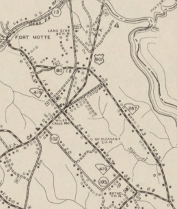
Creation: SC 267 appeared in 1940 as new primary routing, running as a loop from SC 26 (now US 601) through Ft. Motte and back to SC 26 (now S-9-151) near the original Congaree River bridge.
| Adjustments: In 1947, SC 267 was extended southeast as new primary routing to end at SC 33 Lone Star. Also, a separate piece of SC 267 was created as new primary routing from US 15 northwest to SC 6 near Elloree. In 1950, SC 267 north was truncated to Ft. Motte, leaving behind S-9-13 (no longer numbered Wise Rd today). In 1951, the gap of SC 267 from Elloree to Lone Star was placed into the primary system over S-9-18, S-38-38, and SC 6.
In 1952, SC 267 north was rerouted. Instead of going to Fort Motte, it instead replaced S-9-92 to end at US 601 as it does today. The old path to Fort Motte became SC 419.
Improvements: SC 267 was paved from US 601 to Ft. Motte in 1948. SC 267 was paved from US 601 to Lone Star in 1950. SC 267 was paved from Lone Star through Elloree in 1951. SC 267 was paved from US 15 to Elloree in 1952. SC 267 has no multilane segments. Comment: SC 267 provides a back way to get from I-95 to US 601 heading for Camden. Elloree can be bypassed by continuing straight at the SC 267 NB-SC 6 jct. | |||||||||||
Previous: SC 266 |
Next: SC 268
Top | South Carolina Hwy Index
Home
Page last modified 4 July 2015