ROUTE LOG
US 76, US 378: 0 - 0
I-77 (exit 9): 0.1 - 0.1
US 601: 14.8 - 14.9
|
|
Creation: SC 263 appeared in 1938 as new primary routing, running from US 76 east 7 miles (to about where S-40-1790 Old Leesburg Rd crosses Cedar Creek). This is the only SC 262.
Adjustments: In 1940, SC 262 was extended east as new primary routing to SC 26 (now US 601).
In 1941, SC 262 was removed from the very lengthy Old Leesburg Rd (some is S-40-1444 and S-40-1790).
In 1947, SC 262 was downgraded to S-40-18 and S-40-23.
In 1949, SC 262 was restored to the state primary system.
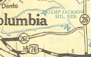
SC 262 appears east of Columbia
1938 Official
|
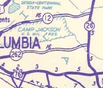
SC 262 extended to SC 26
1940 Official
|
SC 262 decommissioned
1948 Official
|

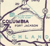
SC 262 returns to action
1949 Official
|
Improvements: SC 262 was paved on its first 3 miles upon inception.
SC 262 was fully paved in 1942.
SC 262 was multilaned from US 76-378 to Fairmont Rd in 1965.
Comment: SC 262 serves as the southern boundary for Fort Jackson for nearly its entire length.
|