< SC 109 | Home | SC 110 ALT | SC 111 >
|
|
|
| ROUTE LOG |
US 29: 0 - 0 I-85 (exit 83): 1.6 - 1.6 Cherokee-Spartanburg Line: 1.9 - 3.5 US 221 ALT, SC 11: 5.3 - 8.8
|
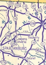
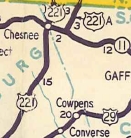
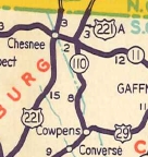
Creation: SC 110 was created in 1942 as new primary routing, running from SC 11 (now Cowpens Battlefield trail) south to the Spartanburg County Line. This is the 2nd SC 110.
| Adjustments: In 1947, SC 110 was downgraded to S-11-28. In 1949, SC 110 was put back into the primary system, plus extended south over S-42-46 to end at US 29 Cowpens.
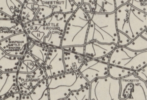
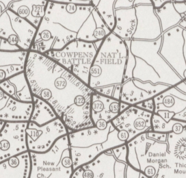
In 1958, SC 110 was removed from S-42-21 Horry Rd and S-42-22 Edgefield Rd to accomodate I-85. Between 1983-86, SC 110 was rebuilt at its northern end in its current configuration to avoid Cowpens Battlefield. The original north end was at what is now the Historic 1781 Green River Rd. Most of the rerouted 110 is no longer road except for McGinnis Rd near S-11-58.
Improvements: Paved since creation; no multilane segments Comment: SC 110 serves the Cowpens National Battlefield from I-85. | Previous SC 110's:
1941 ROUTE LOG US 221, SC 11: 0 - 0 Cherokee-Spartanburg Line: 0.3 - 0.3 SC 110 ALT: 0.4 - 0.7 NC STATE LINE: 2.1 - 2.8 |
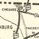
SC 110 #1: Appeared in 1931 as new primary routing, running from SC 11 Chesnee north to North Carolina.
In 1942, SC 110 was renumbered as part of US 221.
|
|||||||||||||
Previous: SC 109 |
Next: SC 110 ALT | SC 111
Top | South Carolina Hwy Index
Home
Page last modified 15 October 2015