< SC 3 | Home | SC 4 ALT | SC 5 >
|
|
|
| ROUTE LOG |
US 78: 0 - 0 SC 118, SC 302 WB: 0.3 - 0.3 SC 302 EB: 12.9 - 13.2 SC 394: 0.6 - 13.8 Orangeburg-Aiken Line: 8.8 - 22.6 SC 39 SB: 4.3 - 26.9 SC 39 NB: 0.1 - 27.0 SC 3 Bus SB: 0.1 - 27.1 SC 3 Bus NB: 0.2 - 27.3 SC 3: 0.8 - 28.1 SC 332: 1.4 - 29.5 US 321: 7.5 - 37.0 SC 400: 12.4 - 49.4 US 301 SB, US 601 SB: 1.2 - 50.6 SC 33: 1.7 - 52.3 US 301 NB, US 601 NB: 0.1 - 52.4 US 21 SB, US 21 Bus: 1.9 - 54.3
|
Creation: An original state route that originally ran from SC 27 (now US 78) west of Windsor, east through Springfield, Orangeburg, and Santee before ending at SC 26 (now US 521) Manning. This is the only SC 4.
|
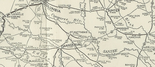
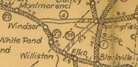
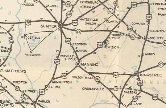
SC 4 original route 1922 Auto Trails Adjustments: In 1923, SC 4 was extended with SC 26 to Alcolu then northeast as new routing through Olanta to end at SC 41 (now US 52) at the Lynches River south of Effingham. Also, SC 4 was rerouted at Springfield to instead head southwest to SC 27 at Williston.
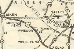
SC 4 extended northeast and rerouted to Williston on the west end 1923 Auto Trails In 1925 or 1926, SC 4 returned to running from Springfield to west of Windsor. The route down to Williston became part of SC 39. In 1927, the original Santee River Bridges were built and SC 4 was placed on them. The old route used today's S-38-82 Antioch Rd to Parler. It is less clear how SC 4 got to the river and Nelsons Ferry near Santee State Park. On the other side of the lake SC 4 used Nelsons Ferry Rd to St Paul. By 1930, SC 4 was removed from Woolbright Rd in the vicintiy of US 176 and SC 47. SC 4 would have used a little SC 31 (now US 176). In 1932, SC 4 was rerouted at the Aiken/Orangeburg line to instead head west to SC 215 (now SC 302) Kitchings Mill. The old route to Windsor is today the lengthy mostly unpaved Oak Ridge Club Rd, S-2-22 Veterans Rd, and unpaved Watermark Dr.
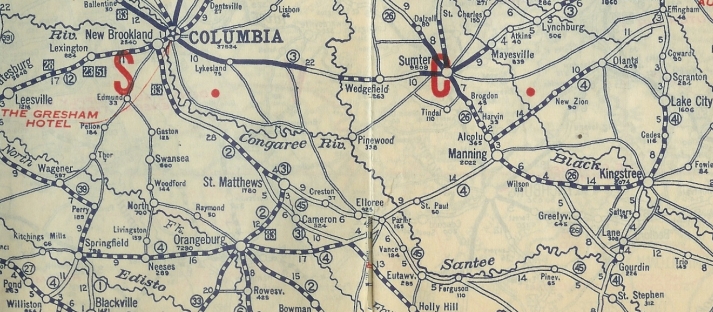
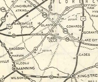
Also in 1932, SC 4 was rerouted at Olanta to instead meet US 17 (now US 52) at Effingham. The old route used SC 341 Hampton St, SC 541, S-21-147 Old No 4 Hwy. In 1933, SC 4 was rerouted at Manning to avoid Alcolu, leaving behind US 521, plus today's S-14-303 Georgia Pacific Rd and US 301 CONN. In 1935, SC 4 east was truncated to US 15 south of Santee, leaving behind US 15 north to Summerton (now US 15-SC 6 CONN; S-38-430 Bass Dr in Santee; abandoned bridge location just west of the standing but abandoned bridge; S-14-230 north of Lake Marion; US 15 to Summerton) and US 301 to Effingham.
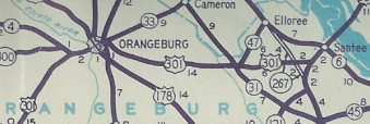
Maps imply that in 1936 or 1937, SC 4 was moved from Whitman Rd to continue on Five Chop Rd to Russell St. Whitman Rd became SC 4 ALT (now S-38-22). By 1940, SC 4 was put on its current bypass of Neeses, leaving behind SC 4 ALT and SC 5 (now S-38-6 Rice St and US 321) In 1947, SC 4 was truncated to US 301 west of Orangeburg, leaving behind US 301 over to Santee (today this is SC 33 and S-38-1 Five Chop Rd within Orangeburg, but still US 301 elsewhere). In 1975 or 1976, SC 4 was extended east with US 301-601, then put on the newly constructed Stonewall Jackson St around to US 21-21 Bus.
In 1980, SC 4 was extended west with SC 302 to end at US 78 Aiken. This extension still does not appear on the main side of the Official Map as of 2015 and only started appearing in the Aiken insets between 1993-96.
SC 4 extended to Aiken 1980 Aiken County Improvements: By 1923 SC 4 was paved only from SC 33 (current US 301-601) east to Orangeburg. SC 4 was paved from Santee to Manning in 1932. In 1934, SC 4 was paved from Manning to Effingham and also for several miles east from Orangeburg. In 1936 or 1937, SC 4 was paved east to SC 47; west to the Aiken County Line. In 1939 the last two segments of SC 4 were paved: SC 47 to US 15 and the Aiken County portion. SC 4 was first multianed on its US 301-601 overlay when it was added in 1975-76. SC 4 was multilaned on its westernmost 2 miles by the late 1980s (not shown on maps until recently). Comment: SC 4 is a useful route from I-26/Orangeburg areas to Aiken/Augusta. I used it regularly for this purpose when I lived in Goose Creek. SC 4 is NOT posted on the US 301-601 overlay, but it is posted at each end of Stonewall Jackson St. | ||||||||||||

Previous: SC 3 |
Next: SC 4 ALT | SC 5
Top | South Carolina Hwy Index
Home
Page last modified 22 July 2016