ROUTE LOG
EXIT 9 US 17: 0 - 0
EXIT 9 SC 7: 0.2 - 0.2
EXIT 11 SC 461: 1.3 - 1.5
EXIT 13 Leeds Ave: 2.5 - 4.0
EXIT 15 SC 642: 1.0 - 5.0
EXIT 16 S-10-62 (Montague Ave): 0.5 - 5.5
EXIT 16 Airport: 0.5 - 6
EXIT 17 I-26 (exit 212): 0.5 - 6.5
EXIT 18 US 52, US 78: 0.5 - 7
EXIT 19 S-10-60 (N. Rhett Ave): 1.5 - 8.5
EXIT 20 S-10-38 (Virginia Ave): 0.5 - 9
Berkeley-Charleston Line: 0.5 - 9.5
EXIT 23 S-8-33 (Cainhoy Rd): 3.5 - 13.0
EXIT 25 Daniel Island: 2.0 - 15.0
Charleston-Berkeley Line: 1.0 - 16.0
EXIT 30 S-10-97 (Long Point Road): 4.0 - 20.0
EXIT 33 I-526 Bus, US 17: 3.0 - 23.0
|
|
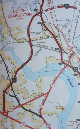
Creation: I-526 was approved by AASHTO in 1989 and was signed on the Mark Clark Expwy for the first time not long after in 1990, when the freeway was connected to I-26.
Adjustments: In 1992, I-526 was extended east to N. Rhett Ave (S-10-60)
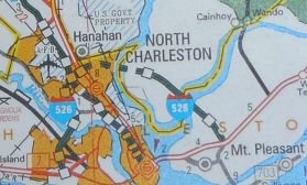
Also in 1992, I-526 was opened from S-8-33 Cainhoy Rd across the Wando River to US 17 in Mt. Pleasant. From Long Point Rd to US 17 was an upgrade to a 2-lane road built about 1980 as an access road from US 17 to the Port Authority facility (the road used the EB ramp from Long Point Rd, which has a bridge on it dated 1980).
The section from S-10-60 across the Cooper River to S-8-33 opened in 1995.

Mark Clark Expwy becomes SC 31
1986 Official
|
Mark Clark Expwy becomes I-526
1990 Official
|
I-526 opens on its eastern end
1992 Official
|
I-526 is completed from US 17 to US 17
1996 Official
|
Improvements: 4 lane freeway since inception. The road was conceived in the 1960's and has some older design features, such as median widths. Construction did not begin until 1979. The Leeds Ave Bridge and the Ashley River Bridge were the first parts, with the bridges dated 1980. The road had originally opened as an unnumbered freeway between Leeds Ave and SC 61 in 1982.
Both the Cooper and Wando River Bridges have truck climbing lanes.
Comment: I-526 is signed at both ends as US 17 Truck (approaching from US 17), but there are no US 17 signs anywhere along the freeway. The route is a continous bridge from just west of I-26 to just east of S-8-33, a distance over 5 miles which is the longest bridge in South Carolina. The Cooper River crossing is directly next to a pulp mill and is frequently both foggy and fragrant.
I-526 was envisioned to continue west and south past US 17 to SC 700, then east back to SC 171 and tie in to the existing James Island Expressway, SC 30. This would require 2 Stono River Bridges.
Not much happened for years with this, but in 2007 the State Infrastructure committed funds to do the extension. However, 10 years of various opposition has made the amount committed well short of a current cost to build it. In 2016-17 Charleston County was pursuing finding a way for them to make up the difference.
As of Aug 2017, Charleston County filed a lawsuit against the infrastructure bank where they request that the damages be the full funding amount. So the project is still in limbo.
There had at one point been a proposal to make the extension non-interstate as a way to save money.
|