< VA 399 | Home | VA 401 >
|
|
|
| ROUTE LOG |
GW PKWY, Alexandria-Fairfax Line: 0 - 0 VA 236: 0.91 - 0.91 GW PKWY: 0.88 - 1.79
|
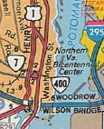
Creation: Appeared as a newly numbered route in Nov 1980 (CTB), although some of this had been US 1 ALT in the 60's. This is the 2nd VA 400.
| Adjustments: None Improvements: Paved and multilaned upon inception Posting: Fully posted; A couple white border shields from 1980 remain. VA 400 is not mentioned from the Beltway although there is a ramp from the Inner Loop to Washington St. Multiplexes: None Legislative names: None Other names: Washington St Scenic Byway: None Comment: It is unclear if VA 400 connects to the rest of the State Highway System. Maps say no. The VDOT route log in 2003 and traffic logs suggest VA 7 and VA 236 end at VA 400.
|
1982-83 Official | Previous VA 400's:
1932 ROUTE LOG US 15, US 58 WB, VA 32, VA 44: 0 - 0 US 58 EB, VA 12: 11 - 11 |
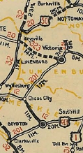
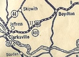
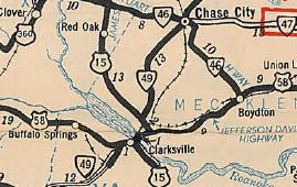
VA 400 #1: Appeared in Aug 1928 as a renumbering of part of VA 201, running from US 15/VA 32/VA 44 near Clarksville east to VA 12 (now VA 92) Boydton. US 401 was also assigned to the entirety of VA 400. Thus, it was a secret route.
In 1932, US 401 was renumbered to US 58. In July 1933, VA 400 was dropped from the route for just US 58. Today, it is still US 58 except it used SR 783 through Finchley; SR 756 into Boydton; one block of SR 707 VA 400 did not appear on officials but is on the 1932 Mecklenburg County Map. At least one commercial map showed it...
|
||||||||||