U.S. Route List | Home
Image: As this 1933 Gousha map shows, U.S. 311 and 411 once shared pavement near Asheboro.
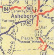
U.S. Route List | Home Image: As this 1933 Gousha map shows, U.S. 311 and 411 once shared pavement near Asheboro. |
|
| U.S. 311 74 miles | ||||||
| The Road: | Starts at I-73/74/U.S.
220 in Randolph County. Ends at N.C. 704/Business U.S. 220 in Rockingham
County.
At one point, U.S. 311 used to run from Rowland, N.C. at least as far north as Roanoake, Virginia (see below). |
|||||
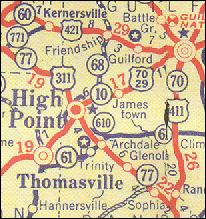
| Towns and Attractions: | Randolph Co.: I-85 exit 111; Archdale (Main Street)
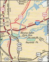
Guilford Co.: High Point (Main Street) Forsyth Co.: Winston-Salem (multiplexed with I-40 between exits 196 and 193; multiplexed with U.S. 52 through downtown; M.L. King Jr. Drive; New Walkertown Road); Walkertown Stokes Co.: Walnut Cove Rockingham Co.: Madison (Academy Street) |
|||||
| Multilane Segments: | Four lanes through Archdale and High Point. Freeway through southeastern Forsyth County, and where signed over I-40 and U.S. 52. Four lanes north of downtown W-S. | |||||
| History: | U.S. 311 is an original 1927 U.S. highway. Its southern
terminus was originally at U.S. 15/N.C. 75 in West End (Moore County).
From there it ran along what were then known as:
In 1996, 311 was again rerouted through Winston-Salem, so that it ran along I-40 and then through downtown over the U.S. 52 freeway. 311 now gets off 52 at the MLK Drive exit north of downtown, and runs east along MLK to New Walkertown Road. |
|||||
|
Comments:
|
U.S. 311 doesn't touch U.S. 11, and hasn't since 1934.
All of 311 south of W-S follows the approximate route of Future I-74. Currently, "END Future I-74" signs are posted at 73/74's intersection with 311. This happens to be 311's southern terminus. |
|||||
| Ideas: | Generally I'm not one to decommission U.S. highways, but if any U.S. route deserves to die, this is the one. Once I-74 is completed to W-S, 311 can easily be done away with south of that city, and demoted to N.C. 311 to the north. | |||||
| U.S. 411 dead | ||||
| Formerly: | Here's the 411 on 411: It followed the general alignment of
today's U.S. 220 -- or technically, Business 220 and Randleman Road south
of Greensboro. It started at U.S. 15 in Richmond County, ran north through
Greensboro, and ended at 311 in Madison (Rockingham County). It was signed
over the original N.C. 70 to the south of Greensboro, and N.C. 704 to the
north. Part of 411 in the Asheboro area was co-signed with 311, as the
scan at the top of the page shows.
411 is shown only on 1933 maps, such as the one at right. It may have existed during parts of 1932 or 1934, but not long enough to show up on any maps from those years. At least it's shown on maps from at least three competing publishers. Before 1933, 411's path was only signed as N.C. 70 and 704; immediately after 1933 came the great renumbering of 1934, when 411 and the state highway designations were eschewed in favor of the newly-minted U.S. 220. Today, U.S. 411 is very much alive and well in Tennessee, Georgia and Alabama. But in North Carolina, 411 was truly a Stealth Highway. |
 |
||
Previous: U.S. 701 | Next: U.S. 13
| All U.S. Highways
Top | NCRoads.com
Home
![]()