All U.S. Highways | Home

All U.S. Highways | Home |
|
| U.S. 15/501 co-signed for 106 miles | |||||||||
| The Road: | Co-signed between Laurinburg (Scotland County) and Durham (Durham County).
Note: 15/501 is cosigned with U.S. 1 through Sanford and much of Lee County. This stretch of road is discussed on the U.S. 1 page. |
||||||||
| Towns and Attractions: | Scotland Co.: Laurinburg
Moore Co.: Aberdeen, Pinehurst, Carthage. Hits North Carolina's most famous traffic circle in Pinehurst. Lee Co.: Sanford Chatham Co.: Pittsboro (Sanford Street, Hillsborough Street) Orange Co.: Chapel Hill (Fordham Boulevard). Crosses I-40 (exit 270) near the Orange/Durham line. The interchange with the Interstate is a diamond, and has been woefully underpowered since I-40's completion in 1988. Durham Co.: Durham (freeway, I-85). At I-85's Duke Street exit, U.S. 501 exits 85 to run north along Duke Street, whereas 15 continues along the Interstate. |
||||||||
| Multilane Segments: | Four lanes around Laurinburg, where 15/501 is cosigned with
U.S. 401.
Four lanes in from Aberdeen at least as far north as the Pinehurst traffic circle. Four lanes or freeway where co-signed with U.S. 1 through Lee County and around Sanford. Four lanes around the south side of Chapel Hill and into Durham. Freeway from South Square Mall in Durham to the two routes' divergence at Duke Street. |
||||||||
| History: |
|
||||||||
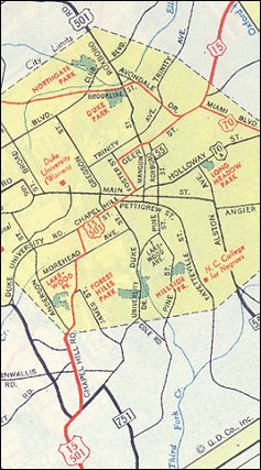
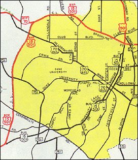
| Comments: | 15/501 is most famous for connecting Chapel Hill and Durham (see photo above). Commentators covering basketball games between Duke and UNC inevitably comment on this fact. In 1999, 15/501 will host a different sporting event: the men's golf U.S. Open, which will be played at Pinehurst #2. | ||||||||
| Ideas: | Upgrade 15/501 to a freeway between Franklin Street and South
Square Mall in Durham. This one's about 15 years overdue. While you're
at it, upgrade I-40 exit 270 to at least a cloverleaf with C/D lanes. A
4-level "Spaghetti Junction" interchange wouldn't be bad, if you could
fit one in.
Name 15/501 through Durham the Terry Sanford Freeway. Couldn't be more appropriate. |
||||||||
| Business U.S. 15/501 21/2 miles | |
| The Road: | Through Laurinburg, Scotland County. |
| Comments: | Also carries part of Business U.S. 401. Was mainline 15/401/501 until it was bypassed in the late 1950s. |
| Business U.S. 15/501 dead | |
| Formerly: | Signed over Columbia Street and East Franklin Street in Chapel
Hill.
Was mainline 15/501 until 1953. Designation lasted from 1953 apparently until the mid-1980s. Was definitely gome by 1989, a fact lost on several cartographers. Nowadays, Columbia Street is N.C. 86, but Franklin Street is unnumbered (West Franklin was once part of defunct Business N.C. 54). A good thing; like the Blue Ridge Parkway, Franklin Street doesn't need to cheapened by a number. |
| Business U.S. 15/501 6 miles | |
| The Road: | Located in Durham, Durham County.
Signed over Chapel Hill Boulevard, University Drive, Roxboro (northbound) and Mangum (southbound) Streets. |
| Comments: | Was mainline 15/501 between 1953 and 1960. North of I-85, Roxboro Road is signed as Business 501 only; 15 continues along northbound I-85. |
| U.S. 15 | |||
| The Road: | Enters Scotland County from South Carolina co-signed with U.S.
401.
Runs about 5 miles before joining U.S. 501 in Laurinburg. Separates from 501 in Durham (Durham County). Runs about 43 miles before crossing into Virginia from Granville County. In total, U.S. 15 runs about 155 miles in the state. |
||
| Towns and Attractions: | Durham Co.: Signed along I-85 between exits 176 (Duke Street,
Durham) and 186. Crosses Falls Lake.
Granville Co.: Creedmoor; Oxford (Lewis Street; College Street) |
||
| Multilane Segments: | Apparently there's a short four-lane stratch a bit south of Laurinburg. Freeway where signed over I-85. | ||
| History: | U.S. 15 was a preliminary 1925-26 U.S. highway. It
was proposed to run from Wilmington to Wilson and north to Virginia, along
modern-day U.S. 117 and 301. This routing never
existed in reality.
In 1927, 15 was born as an original U.S. highway. Its southern terminus was in Rockingham (not Laurinburg), and north of there it ran entirely over the original N.C. 75 all the way to Virginia. From Rockingham it ran along what are now U.S. 220, N.C. 73 and N.C. 211 to get to Pinehurst; north of Pinehurst its general routing is the same as today's. In 1934, 15 was rerouted south of Pinehurst so that it ran to Laurinburg and into South Carolina, as it does today. Also in 1934, 15/501 was created; the history of 15 after this date is described under the 15/501 entry above. The freeway northeast of Durham was completed as part of I-85 in 1965 or 1966. Before that time, 15 was signed over Geer Street for several miles north of downtown Durham. |
||
| U.S. 15A dead | ||||||
| Formerly: |
|
|||||
| U.S. 501 | |||
| The Road: | Enters Robeson County from South Carolina.
Runs about 21 miles before joining U.S. 15 in Laurinburg. Separates from 15 in Durham. Runs for about 44 miles before crossing into Virginia from Person County. In all, U.S. 501 runs for about 165 miles in the state. |
||
| Towns and Attractions: | Robeson Co.: I-95 exit 1; SotB; Rowland (Bond Street, Main Street)
Durham Co.: Durham (Duke Street; Roxboro Road) Person Co.: Roxboro (Madison Boulevard) |
||
| Multilane Segments: | Four lanes between I-85 in Durham and Roxboro. | ||
| History: | U.S. 501 was a preliminary 1925-26 U.S. highway that
had its southern terminus in Durham, and from there ran north through Roxboro
into Virginia just as it does today. It was not changed for the official
debut of the U.S. highways system in 1927 (they acutally got one right).
501's original state highway designation was N.C. 13; this was changed
to N.C. 55 around 1930.
In 1934, the 15/501 multiplex was created when 501 was routed along U.S. 15 from Durham all the way south to Laurinburg. From Laurinburg it was sent to Rowland and into S.C. along what had been N.C. 241, 71 and 22. This rerouting was part of the great renumbering of 1934. North of Durham, mainline U.S. 501 was routed over the entire length of Roxboro Street and Roxboro Road. While the 15/501 freeway bypass was opened around 1960, mainline 501 wasn't switched from Roxboro to Duke Street until another year or two later. 501 north of Durham was widened to four lanes: |
||
| Business U.S. 501 3 miles | |
| The Road: | Roxboro Street between I-85 and Duke Street, in Durham, Durham County. |
| History: | Dates back to 1961 or 1962. Was mainline 501 before that. |
Previous: U.S. 13 | Next: U.S.
17 | All U.S. Highways
Top | NCRoads.com
Home
![]()