| N.C.
80 34 miles |
|
|
|
|
| The Road: |
|
Begins at US 70 Pleasant Garden (McDowell County) and ends at NC 226-A above Bandana (Mitchell County).
|
Towns and Attractions: |
|
McDowell Co: Lake Tahoma
Yancey Co: Blue Ridge Pkwy
Mitchell Co: None
|
History: |
|
NC 80 was born in 1940 as a renumbering of NC 104, running from US 70 north to NC 26 (now NC 226) Loafers Glory
In the late 1990s, NC 80 north was truncated to its current ending, replaced by the second NC 226-A.
NC 104 in 1940
|
NC 80 replaces NC 104
|
NC 80 truncated to NC 226-A #2
|
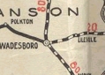
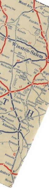
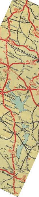
The first NC 80 was an original state highway. It began at the South Carolina State Line at McFarlan, where US 52 crosses today. It proceeded up US 52 to Morven, then used "Old US 52" northward. NC 80 picked up 52 again but near Wadesboro likely used Air Nat'l Guard/Mt Beulah Rds (before 1930), then it picked up SR 1131 Morven Rd to Wadesboro where it cut west on Morgan St to NC 109.
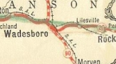
NC 80 followed NC 109 through Wadesboro, then picked up Leak Ferry Rd through Pinkston north to US 52. NC 80 used Pinkston-River Rd from Cedar Hill to the Rocky River
Just across Rocky River, NC 80 cut over to Riverview Rd to Norwood, then used Pee Dee St back to US 52. NC 80 followed US 52 to Albemarle, then used 1st St through town. NC 80 initially used Old Salisbury Rd northwest to Austin Mills, then Austin Rd east to US 52 at Halls Ferry Jct. NC 80 then used US 52 to New London, where it followed Main St through town.
NC 80 picked back up US 52 through Richfield to Misenheimer, then used Glenmore Rd and "Old Route 80" to Gold Hill. It appears NC 80 used Sides Rd and bypassed Rockwell, then used Main St and Faith Rd to South Salisbury.
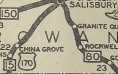
NC 80 used Innis St through Salisbury, then picked up US 601. 80 used 601 to Mocksville except used loop roads Boxwood Church Rd, Pleasant Acre Dr and another loop road above Ephesus.
NC 80 used US 601 north of Mocksville to NC 801, then slid east on 801 to Four Corners Rd. NC 80 used that to Courtney, then Courtney Rd back to US 601. NC 80 used 601 to Yadkinville.
North of Yadkinville, NC 80 veered east on Country Club Rd which winds its waty back around to US 601. NC 80 followed US 601 through Boonboro and Fairview, then used US 601 Business through Dobson.
NC 80 used the lengthy "Old US 601" through White PLains to Mt. Airy. NC 80 used US 601 and old 601 into downtown Mt. Airy, then used NC 103 to the Virginia State Line.
In 1926, NC 80 was rerouted in Wadesboro to duplex with NC 20 (now US 74) and use today's US 52 north to leave town;
NC 80 crosses NC 20
|
NC 80 duplexes with NC 20
|
By 1929, NC 80 was routed through Rockwell.
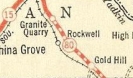
NC 80 avoids Rockwell
|
NC 80 through Rockwell
|
By 1930, NC 80 used modern US 52 in the Granite Quarry to Salisbury stretch; also, NC 80 was removed from Boxwood Church Rd
In 1932, US 601 was added to NC 80 from Salisbury to Mt. Airy.
Original NC 80
|
US 601 added to NC 80
|
In late 1934, NC 80 north was truncated to Mt. Airy, leaving behind US 601 Mt. Airy to Salisbury and US 52 from Salisbury to South Carolina.
In 1940, the remaining piece of original NC 80 was renumbered as NC 103.
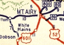
NC 80 survives above Mt. Airy
|
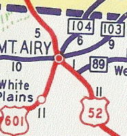
NC 103 replacing NC 80
|
|
Comment: |
|
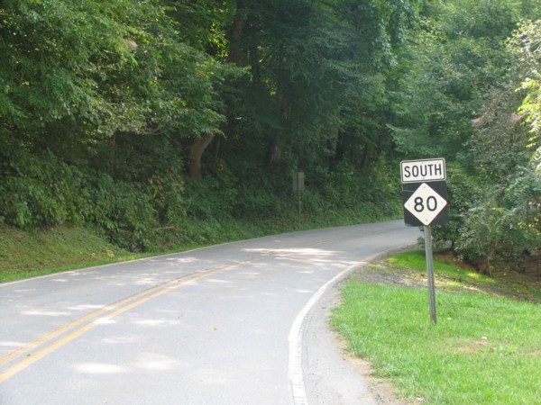
NC 80 is largely a difficult, winding drive. Many people are undoubtedly surprised when they try to use it from US 70 to the Blue Ridge Pkwy, presumably to get to Mt. Mitchell. Most maps imply this part of NC 80 to be quite reasonable. It is not.
|