< US 15 | Home | US 17 | US 17 Bus | US 17-Y | US 21 >
|
|
|
| ROUTE LOG |
US 17, US 21 SB: 0 - 0 Hampton-Beaufort Line: 2.4 - 2.4 SC 68: 1.2 - 3.6 Colleton-Hampton Line: 2.2 - 5.8 US 21 NB: 1.6 - 7.4 SC 63 WB: 15.0 - 22.4 SC 303: 1.5 - 23.9 SC 63 EB: 0.2 - 24.1 US 15: 0.1 - 24.2 SC 64 Bus WB: 0.3 - 24.5 SC 64 Bus EB: 0.6 - 25.1 SC 64: 0.8 - 25.9 SC 651: 8.8 - 34.7 Dorchester-Colleton Line: 5.7 - 40.4 SC 61 WB: 7.3 - 47.7 SC 61 EB: 0.3 - 48.0 SC 642: 1.8 - 49.8 SC 91: 1.5 - 51.3 US 78: 5.0 - 56.3 Berkeley-Dorchester Line: 0.6 - 56.9 SC 91: 0.2 - 57.1 I-26 (exit 199): 0.8 - 57.9 US 176: 3.8 - 61.7 SC 6: 10.8 - 72.5 US 52 SB: 1.5 - 74.0 SC 402: 1.6 - 75.6 US 52 NB: 0.3 - 75.9 SC 45 WB: 14.3 - 90.2 SC 41 SB, SC 45 EB: 3.8 - 94 Berkeley-Georgetown Line: 1.7 - 95.7 SC 41 NB: 4.2 - 99.9 US 521 NB: 13.8 - 113.7 US 521 SB: 9.5 - 123.2 US 17, US 701: 0.2 - 123.4
|
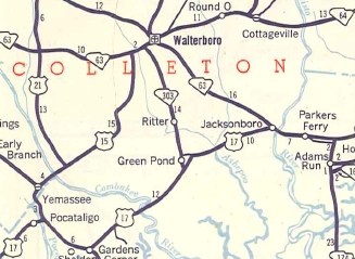
Creation: US 17 ALT appeared in 1952 as a renumbering of US 15 from Pocotaligo to Walterboro...
|
...and as a renumbering of SC 64 from Walterboro to Georgetown. This is the 7th of 8 US 17 ALTs. 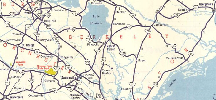
SC 64 Walterboro to Georgetown 1951 Official

US 17 ALT Walterboro to Georgetown 1952 Official Adjustments: None Improvements: Fully paved upon designation The first piece of US 17 ALT to be 4-laned was in 1970 from US 78 to I-26. In 1974, US 17 ALT was 4-laned within the Georgetown City Limits. In 1975, US 17 ALT was 4-laned on its US 52 duplex in Moncks Corner. In 1979, US 17 ALT was 4-laned on its SC 63 duplex in Walterboro. In 1988, US 17 ALT was 4-laned on its US 521 duplex west of Georgetown. In 2001, US 17 ALT was 4-laned from I-26 to S-8-62 College Park Rd. In 2007 or 2008, US 17 ALT was 4-laned from S-8-62 to US 176. In 2014 or 2015, US 17 ALT was 4-laned from US 176 to S-8-9. In 2016, US 17 ALT was 4-laned from S-8-9 to US 52. Comment: US 17 ALT is no longer (if it ever was) a good viable alternative to US 17. It would make much more sense to have it redesignated as US 15 below Walterboro and US 701 from Walterboro to Georgetown. US 17 ALT is especially slow through Summerville and Walterboro. US 17 ALT has posted TRUCK routes in Summerville (uses SC 91) and Walterboro (uses SC 64, Robertson Blvd, and SC 303). | Previous US 17 ALT's:
1940 ROUTE LOG US 17, SC 128: 0 - 0 SC 336: 0.3 - 0.3 SC 128 NB: 0.2 - 0.5 US 17, SC 128 SB: 0.3 - 0.8 1946 ROUTE LOG SC 28: 0 - 0 SC 367: 0.4 - 0.4 US 17, US 21: 0.3 - 0.7 US 21 ALT, SC 28, SC 286: 0.3 - 1.0 1939 ROUTE LOG US 17: 0 - 0 SC 174: 5.1 - 5.1 US 17: 13.5 - 18.6 1946 ROUTE LOG US 17: 0 - 0 US 17, US 701: 5.0 - 5.0 1946 ROUTE LOG US 17: 0 - 0 US 17: 1.0 - 1.0 1946 ROUTE LOG US 17: 0 - 0 SC 128 ALT, SC 336: 0.5 - 0.5 SC 128: 0.2 - 0.7 US 17: 0.3 - 1.0 1996 ROUTE LOG GA STATE LINE: 0 - 0 SC 170 ALT: 4.1 - 4.1 US 17: 2.5 - 6.6 |
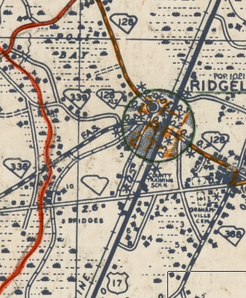
US 17 ALT #1: Appeared about 1936 as a loop off US 17 (now S-27-32 Green St) in Ridgeville using SC 36 3rd Ave, Russell St, and Main St.
Between 1941-46, US 17 ALT was renumbered as SC 128 ALT. Today it is US 278, SC 336 CONN, and SC 336.
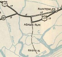
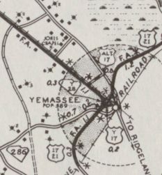
US 17 ALT #2: Created Feb 1937 (SCDOT) as new BELT routing in Yemassee, ran at least from SC 28 (now SC 68) east across US 17 then into Yemassee to end at US 17-21 (now S-7-3). In 1947, US 17 ALT was downgraded to S-25-10 Church St. Some of this is now S-25-13 Old Salkehatchie Hwy as well. See scan after US 17 ALT #5 entry. US 17 ALT #3: Appeared around 1938 as a renumbering of US 17 from Rantowles to Parkers Ferry via Adams Run. About 1939, US 17 ALT was downgraded to secondary status but soon after became SC 162, part of SC 174, and what is now S-10-40.
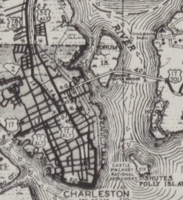
US 17 ALT #4: Created about 1940 as a huge loop south of US 17 in downtown Charleston. In 1947, US 17 ALT was downgraded to S-10-29. Today this is US 17 NB lanes on Cannon St; S-10-46 Rutledge Ave; S-10-29 Murray Blvd and E. Bay St; US 52 SPUR E. Bay St; S-10-404 Calhoun St; S-10-107 Meeting St. US 17 ALT #5: Created about 1940 as a loop off US 17 in Myrtle Beach. In 1947, US 17 ALT was downgraded to S-26-28 though later became part of SC 73. Today this is just Ocean Blvd.
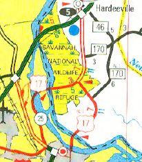
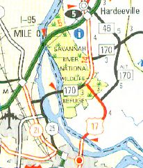
US 17 ALT #6: Created between 1941-46 as a renumbering of US 17 on Green St in Ridgeland. In 1947, US 17 ALT was downgraded to S-27-32. US 17 ALT #8: Created as new construction in 1954. Ran from US 17 (current US 17-SC 170 south split) southeast to a new toll bridge into Savannah, Georgia. This became mainline US 17 in about 1994. In 1997, US 17 ALT was renumbered as part of mainline US 17.
| |||||||||||||||||


Previous: US 15 |
Next: US 17 | US 17 Bus | US 17-Y | US 21
Top | South Carolina Hwy Index
Home
Page last modified 22 April 2026