< US 123 | Home | US 178 >
|
|
|
| ROUTE LOG |
US 52: 0 - 0 US 17 ALT: 5.8 - 5.8 SC 311: 19.1 - 24.9 SC 27: 1.2 - 26.1 Orangeburg-Berkeley Line: 1.1 - 27.2 SC 453 SB: 4.6 - 31.8 SC 453 NB: 0.2 - 32 SC 310: 0.8 - 32.8 SC 314: 0.9 - 33.7 US 15, SC 45: 3.6 - 37.3 I-95 (exit 90): 2.6 - 39.9 SC 210: 1 - 40.9 US 301: 6.9 - 47.8 Calhoun-Orangeburg Line: 0.9 - 48.7 SC 33: 7.9 - 56.6 US 601: 6.9 - 63.5 SC 6 EB: 3.7 - 67.2 SC 6 WB: 0.5 - 67.7 US 21 SB: 11.9 - 79.6 Lexington-Calhoun Line: 6.1 - 85.7 I-26 (exit 119): 0.7 - 86.4 US 321 SB: 1.9 - 88.3 I-77: 3 - 91.3 I-26 (exit 115): 0.4 - 91.7 SC 2: 1 - 92.7 SC 302: 1.6 - 94.3 SC 35: 0.9 - 95.2 SC 2: 0.8 - 96 Richland-Lexington Line: 0.6 - 96.6 US 1, US 78: 1 - 97.6 SC 12: 0.4 - 98 I-126 Bus WB, US 76 WB: 0.5 - 98.5 SC 48: 0.6 - 99.1 I-126 Bus END, US 76 EB: 0.1 - 99.2 US 21 NB, US 321 NB: 0.5 - 99.7 SC 16: 1 - 100.7 I-20 (exit 65): 2.7 - 103.4 SC 60: 4.6 - 108 I-26 (exit 101), US 76 EB: 1.7 - 109.7 US 76 WB: 3.4 - 113.1 I-26 (exit 97): 2 - 115.1 Newberry-Richland Line: 7.9 - 123 SC 213: 3 - 126 SC 202: 2.3 - 128.3 SC 773: 1.5 - 129.8 SC 219: 1.8 - 131.6 SC 34: 5.7 - 137.3 SC 121 SB: 5.7 - 144 SC 72 WB: 7.3 - 151.3 Union-Newberry Line: 0.5 - 151.8 SC 72 EB, SC 121 NB: 1 - 152.8 SC 18, SC 215 SB: 14.1 - 166.9 SC 496: 1.4 - 168.3 SC 49: 0.3 - 168.6 SC 215 NB: 1.2 - 169.8 Spartanburg-Union Line: 11.9 - 181.7 SC 150: 1 - 182.7 SC 9 EB, SC 295: 2 - 184.7 I-585 BEGIN, US 29: 8.7 - 193.4 SC 296: 0.4 - 193.8 US 221: 1.2 - 195 SC 9 WB: 0.3 - 195.3 I-85 Bus (exit 5), I-585 END: 1.9 - 197.2 I-85 (exit 72): 1 - 198.2 SC 56: 0.4 - 198.6 I-26 (exit 15): 3 - 201.6 SC 292: 3.4 - 205 SC 357: 6.4 - 211.4 SC 11: 0.4 - 211.8 SC 14: 4.7 - 216.5 Greenville-Spartanburg Line: 1.9 - 218.4 NC STATE LINE: 0.8 - 219.2
|
Creation: Appeared in 1927 as an original US route. Originally ran from US 76 Newberry to North Carolina above Inman. US 176 followed today's SC 121 from Newberry to Whitmire; current US 176 from Whitmire to Union; current SC 215 from Union to Pauline; current SC 56 (for the most part) from Pauline through Spartanburg; today's US 176 corridor from there to North Carolina. US 176 was added to SC 19 for its entire run.
| In Spartanburg, US 176 originally used Union St to Dean St to Main St to Magnolia St to Howard St Adjustments: By 1932, US 176 was moved to Pine St instead of Union St. Union St. became unnumbered but is now part of SC 56. It appears US 176 used Country Club Rd. to cut between current SC 56 and Pine St. In 1933, US 176 was moved back to the Union-Dean route. In 1937 or 1938, US 176 was rerouted to use Church St. north of Main St (US 29) to Asheville Hwy. The Magnolia-Howard St. routing became US 176 OPT. Today Howard St. is S-42-2. By 1939, SC 56 was added as a multiplex from Pauline to Spartanburg. In 1949, US 176 was rerouted between Union and Spartanburg, by heading north to Jonesville (replacing part of SC 11) and multiplexing with SC 9 from Jonesville through Pacolet to Spartanburg, along Pine St. The old way became an extended SC 215 from Union to Pauline and SC 56 remained on the road from Pauline to Spartanburg. In 1951 or 1952, US 176 was rerouted below Whitmire and extended southeast through Columbia, Cameron, and Holly Hill before ending at US 52 Goose Creek. This replaced all of SC 177 #2, created a US 76 multiplex in the Ballentine-Columbia area, created a US 21 multiplex in the Columbia-Sandy Run area, and replaced all of SC 31. The old piece from Newberry north to old SC 177 became an extended SC 19 (SC 121 today). Originally, US 176 in Columbia followed Main St to Elmwood, then west to Assembly, south to Gervais, and followed US 1 west across the Saluda River (this was a 6-plex of routes: US 1-21-176-321-378 and SC 215). US 176 followed US 1 to Charleston Hwy (SC 602's beginning) before heading south towards Dixiana. Between 1954-58, US 176 was rerouted in Columbia to continue south on Assembly to Blossom St before heading west across the Saluda River on the current US 176 bridge. The old route remained US 1-378 and SC 602, with a piece of Charleston Hwy becoming a US 1-21 connector. In 1957 or 1958, US 176 was placed on a new bypass west of Union, leaving behind US 176 Business (current SC 18). In 1974 or 1975, US 176 was given a western bypass of Inman, leaving behind S-42-11 and S-42-13. US 176 was removed from Assembly St in Columbia and rerouted along Huger St like today in 1978 or 1979. Assembly St became an extended SC 48. About 1989 or 1990, US 176 was rerouted north of Union onto new 4-lane construction as it runs today. For a while, US 176 ended at S-44-12 and used it to jog east to Jonesville. The old route became part of SC 18 and the SC 9 part remained. US 176 was taken off S-44-12 and put on more new 4-lane routing in 1992. Improvements: Fully paved upon designation only in the immediate Spartanburg area. In 1928, US 176 was paved from the NC Line down to a little below Pauline. By 1932, US 176 was all paved except between Whitmire and Union. US 176 was finally fully paved in 1934. The first pieces of US 176 to be 4-lane were in place by 1964: SC 56 to east of US 29; SC 72 multiplex; Broad River to SC 16; the entire US 321 multiplex. Between 1968-70, US 176 was 4-laned between SC 60 and the Broad River and also from I-26 to SC 56. Between 1974-75, US 176 was 4-laned from I-26 west to SC 292, and east of Spartanburg almost to Pacolet. No official maps have ever shown that the Union bypass is 4-lane, but it was already that way the first time I drove it in 1987. The new construction of US 176 between Union and near Pacolet were 4-laned upon completion as described above. The first couple miles off US 52 were 4-laned by 1993. In 1997, US 176 was 4-laned between US 17 ALT and US 52. Comment: US 176 was the first US route I ever completed, and it is the longest US route I've driven all at once. US 176 below Columbia follows the Old State Road, which was an important route in the early days of South Carolina. US 176 also has a Whitmire bypass that I cannot discern the creation of. It was there in 1987, though. US 176 has also been rerouted just east of I-26 exit 115 to bypass the Kodak-Eastman Plant. I don't know when this was done (done by 1986, though) and the old road goes right through the center of the facility. US 176 below Columbia has many stretches of straight road, up to 11 miles long. US 176 TRUCK has been signed around the south side of Holly Hill since the early 90's, using S-38-68. |
|||||
| US 176 Business Decommissioned | |||
| Previous US 176 Business: |
US 176 Business: Appeared in 1957 or 1958 as Union was bypassed to the west. This route had been part of SC 19 originally. Used Thompson Blvd. and S. Pinckney St. I don't recall if any of this was multilaned.
US 176 Business was renumbered as part of SC 18 in 1989 or 1990, when the new routing toward Spartanburg was first opened. When I drove this in 1987, there was still a carolina cutout at the SC 49 jct in downtown. |
||
| US 176 OPT Decommissioned | |||
| Previous US 176 OPT: |
US 176 OPT: Appeared in 1937 or 1938 as a renumbering of US 176 in Spartanburg, which moved to today's SC 56 routing along Church St. and Asheville Hwy. This was on Magnolia and Howard Streets. The west end of US 176 OPT was at today's Hearon Circle and I-85 BUS jct.
US 176 OPT was downgraded to S-42-2 in 1948. US 176 OPT was shown explicitly on the 1939 Texaco Map. I have no other Spartanburg insets from 1938-53 to check if this was ever switched to US 176 ALT, but the 1946 Mobilgas shows this clearly as a US Route of some sort. 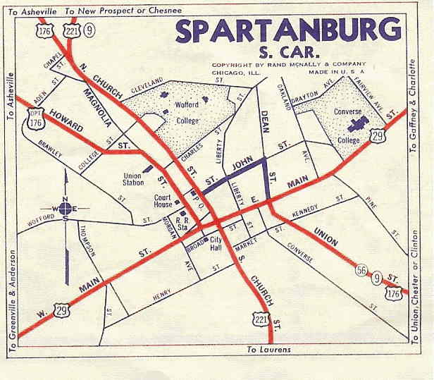
|
||
Last Update: 28 July 2005
Previous: US 123 |
Next: US 178
Top | South Carolina Hwy Index
Home