Previous SC 711's:
1946 ROUTE LOG
US 17: 0 - 0
SC 711 ALT: 1.2 - 1.2
?: 0.7 - 1.9
|
|
SC 711: Appeared in 1939 as a new primary route from US 17 to Pawleys Island. It appears SC 711 headed up the coast to end at the current S-22-10/46 intersection. The road back west to US 17 is shown as primary on the 1943 Georgetown County map but unlabeled. It could be a second SC 711 ALT or US 17 ALT or something else entirely.
In 1947, SC 711 was downgraded to S-22-10. Today only the beachfront part is S-22-10. The road southwest back to US 17 is now S-22-266.
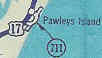
SC 711 out to Pawleys Island
1939 Official
|
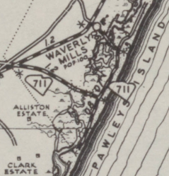
SC 711 on Pawleys Island
Notice the primary route intersection between the road northwest to US 17 and SC 711
If this were the same route there would be no distance point marker
1943 Georgetown County
|
|