Previous SC 691's:
1946 ROUTE LOG
SC 33: 0 - 0
Calhoun-Orangeburg Line: 7.0 - 7.0
SC 31: 2.4 - 9.4
SC 6 EB: 4.5 - 13.9
SC 26: 0.7 - 14.6
SC 117 SB:: 0.3 - 14.9
SC 6 WB: 0.3 - 15.2
SC 117 NB: 0.1 - 15.3
SC 235 EB: 5.4 - 20.7
SC 235 WB: 1.4 - 22.1
US 21, SC 2: 1.6 - 23.7
|
|
SC 691: Appeared in April 1938 (SCDOT) as new primary routing. Ran from SC 69 (current SC 33) Orangeburg northeast 6 miles to the Calhoun County Line.
In 1940, SC 691 was extended to loop around to St. Matthews, then continue northwest to end at US 21-SC 2 (current US 176). This made SC 691 into a 22 mile route.
In 1947, SC 692 was downgraded to S-38-29, S-9-20 (the east-west portion is now S-9-45), SC 6 through St Matthews; a bit of S-9-24, and S-9-21 (the east-west portion from US 176 is now S-9-24).
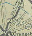
SC 691 appears out of Orangeburg
1938 Official
|
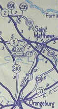
SC 691 extended way around Calhoun County
1940 Official
|
|