ROUTE LOG
US 178: 0 - 0
SC 8 SB: 6.0 - 6.0
SC 8 NB: 0.4 - 6.4
US 123: 0.2 - 6.6
SC 93 WB: 0.8 - 7.4
SC 93 EB: 0.1 - 7.5
SC 183: 4.1 - 11.6
SC 186: 3.0 - 14.6
SC 8: 6.4 - 21.0
|
|
Creation: SC 135 appeared in 1939 as new primary routing, running from SC 13 (now SC 93) Easley north to SC 186 near Dacusville. This is the only SC 135.
Adjustments: In 1940, SC 135 was extended as new primary routing both directions to its current endpoints.
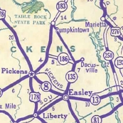
SC 135 appears in Pickens County
1939 Official
|
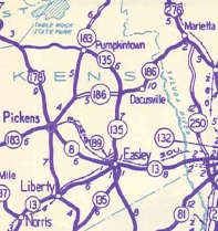
SC 135 extended in both directions
1940 Official
|
Between 1941-53, SC 135 was removed from S-39-35 and S-39-117 (now also S-39-35) in the area of present SC 183 and also from Crossroads Church Rd further north.
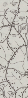
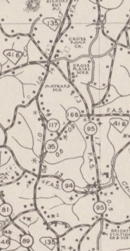
SC 135 original routing north of Easley
1940 Pickens County
|
SC 135 straightened out
1953 Pickens County
|
County maps aren't detailed enough to show it, but about 1970, SC 135 was removed from a brief overlay with SC 93 when the Russell St RR crossing was closed and instead one opened on Pendleton St, with SC 135 using Main St to jog between the two instead of SC 93.
Sometime after 1994, SC 135 was removed from S-39-411 Cherish Dr at the southern SC 8 split.
Improvements: SC 135 was paved upon designation
Sc 135 is multilaned from the north SC 8 split north to almost 2nd St in Easley, back to at least the late 1980s.
Comment: SC 135 essentially provides a bypass for SC 8 north of Easley that avoids Pickens; SC 135 is the main way to get from Anderson to Easley (via US 178)
It appears that SC 135 was one of the last state routes to have SC shield route postings.
|