< SC 119 | Home | SC 121 >
|
|
|
| ROUTE LOG |
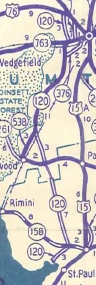
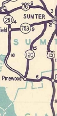
SC 261: 0 - 0 SC 763 WB: 14.2 - 14.2 SC 763 EB: 0.7 - 14.9 US 76, US 378: 2.6 - 17.5
|
Creation: SC 120 appeared in 1942 as new primary routing, running from US 76 northwest of Sumter south to SC 261 east of Pinewood, then after a break, from the Clarendon-Sumter Line across SC 158 (now S-14-26) belser Crossroads to end at today's S-14-76. This is the only SC 120.
| Adjustments: Most of SC 120 south of SC 158 was shown as proposed routing, which appears to have been built while it was still SC 120. It is unclear if the gap between SC 261 and Clarendon County was put into the primary system or not. In 1947, SC 120 north was truncated to SC 763 west of Sumter, leaving behind S-43-27. SC 120 south was truncated and rerouted to end at SC 261 (now S-43-621 Clark St) Pinewood (replacing SC 538). The old route south past SC 158 became S-43-29 and S-14-41. In 1949, SC 120 was extended south 2 blocks to meet the rerouted SC 261 on Fulton St. In 1958, SC 120 was re-extended over S-43-27 north to US 76-378. In 1964, SC 120-763 was removed from Old Liberty St across Second Millpond. Improvements: SC 120 was paved between S-43-29 and SC 763 at designation All parts of SC 120 were paved from 1947 forward. SC 120 was multilaned on its SC 763 overlay in 1964. SC 120 was multilaned from SC 763 south to S-43-422 Stadium Rd in 1988. SC 120 was multilaned from US 76-378 south to Wesmark Blvd between 2008-12 (GMSV). Comment: SC 120 skirts the east edge of Manchester State Forest. If the new bridge over Lake Marion is ever built between Lone Star and Rimini, will SC 120 be renumbered or extended????
| ||||||||

Previous: SC 119 |
Next: SC 121
Top | South Carolina Hwy Index
Home
Page last modified 27 September 2015