 |
From:  Beaufort NAS (Beaufort County) Beaufort NAS (Beaufort County)
To: Laurel Bay (Beaufort County)
Total Length: 3.0 miles
|
|
|
|
|
ROUTE LOG
US 21: 0 - 0
END SC 116: 3.0 - 3.0
|
|
Creation: SC 116 appears as a dotted line on the 1960 official and open as new construction in 1961 running as it does today. This is the 2nd SC 116.
Adjustments: None
Improvements: Paved since creation; no multilane segments
Comment: SC 116 connects the Naval Air Station to the Capehart Housing Project.
|
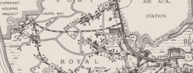
SC 116 west of Beaufort
1963 Beaufort County
|
|
| Previous SC 116's:
1947 ROUTE LOG
US 1: 0 - 0
SC 113: 8.9 - 8.9
|
|
SC 116 #1: Appeared in 1940 as new primary routing, running from US 1 Leesville east to SC 113 (now S-32-37) where today's Exit 44 on I-20 is located.
In 1947, SC 116 was downgraded to S-32-34.
| 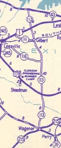
SC 116 out of Leesville
1940 Official
|