< SC 79 | Home | SC 81 >
|
|
|
| ROUTE LOG |
SC 14: 0 - 0 Spartanburg-Greenville Line: 0.6 - 0.6 SC 101: 1.5 - 2.1 SC 290: 2.0 - 4.1 US 29: 1.5 - 5.6
|
Creation: Opened in July 2002 as new construction (per Greenville News). Originally ran from SC 101 to US 29 on the east side of Greer. This is the 2nd SC 80.
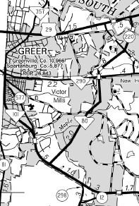
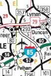
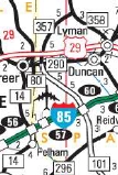
| Adjustments: In April 2005, SC 80 was extended southwest to SC 14 (per Greenville News). Improvements: Fully paved and multilaned upon designation. Comment: SC 80 serves as a bypass of Greer connecting US 29 to I-85 near the GSP Airport. According to the Greenville News, SC 80 was first proposed by the City of Greer in 1999 to be numbered as part of SC 357. Evidently this did not get approved by SCDOT. Although open since 2002, the 2005 Official Map is the first to show SC 80. All issues since 2005 either show SC 80 running to the wrong location or following SC 14 south to I-85. The 2005 Spartanburg County map shows the portion between SC 290 and US 29 as S-42-220 so SC 80 may have briefly only run SC 101 to SC 290 first.
| Previous SC 80's:
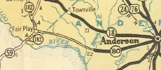
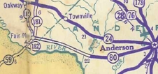
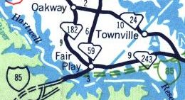
1961 ROUTE LOG SC 59: 0 - 0 SC 243: 1.2 - 1.2 Anderson-Oconee Line: 0.2 - 1.4 SC 187: 10.9 - 12.3 SC 28: 7.2 - 19.5 SC 24: 1.3 - 20.8 |
SC 80 #1: Appeared in July 1937 (SCDOT) as new primary routing, running from SC 18 (now SC 24) Anderson west to the Seneca River bridge.
In Nov 1937 (SCDOT), SC 80 was extended west to the Oconee County Line as new primary routing. In Dec 1937 (SCDOT), SC 80 was extended west as new primary routing to end at SC 181 (now SC 59) Fair Play. In 1962, SC 80 was decommissioned when Lake Hartwell was formed and it was decided not to build additional bridges (presumably with SC 24-243 parallel and nearby). East out of fair Play became part of SC 243; S-37-23; S-4-25 and S-4-23 (now all S-4-23) west of Lake Hartwell; S-4-22 east of Lake Hartwell. About 3 miles total are underwater or nearly so.
|
||||||||||||
Previous: SC 79 |
Next: SC 81
Top | South Carolina Hwy Index
Home
Page last modified 22 July 2017