< SC 65 | Home | SC 67 >
|
|
|
| ROUTE LOG |
SC 56: 0 - 0 US 76: 2.7 - 2.7 I-26 (exit 60): 3.7 - 6.4 Newberry-Laurens Line: 3.7 - 10.1 SC 72: 8.2 - 18.3
|
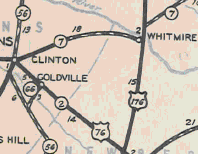
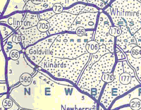
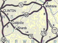
Creation: SC 66 appeared in May 1933 (SCDOT) as new primary routing, running from US 76/SC 2 Goldville (now Joanna) west to SC 56. This is the only SC 66.
| Adjustments: In 1942, a second piece of SC 66 was created, running from SC 706 (current S-36-32) Eisons Crossroads west to the Laurens County Line. In 1947, the gap in SC 66 between Goldville and Newberry County was put into the primary system, plus SC 66 was extended northwest replacing SC 706 to end at SC 72 Whitmire. Between 1948-51, SC 66 was removed from S-36-51 Broome St in Whitmire and placed on its Central/Park/Glenn routing. Improvements: SC 66 was fully paved in 1941; no multilane sections exist on SC 66. Comment: SC 66 travels through the heart of Sumter National Forest. SC 66 must not be that great...signs on SC 72 tell you to follow SC 72 to I-26.
| ||||||||
Previous: SC 65 |
Next: SC 67
Top | South Carolina Hwy Index
Home
Page last modified 20 November 2015