U.S. 74
< 70 | Home | 74-A | 74 Bus | 76 >
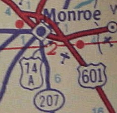
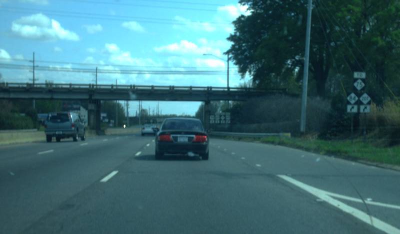
Photo: US 74's Bypass of Monroe at NC 207 (Mapmikey)
| U.S. 74 463 miles | |||
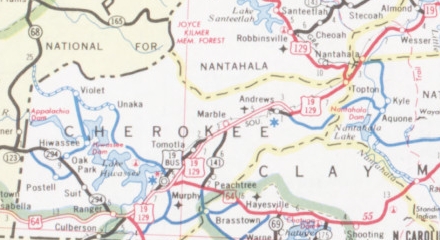
| The Road: | Enters from Tennessee near Wolf Creek (Cherokee County) and ends at the northeaster end of Wrightsville Beach (New Hanover County). Nationally the road runs from Wrightsville Beach to I-75 at Cleveland, TN | Towns and Attractions: | Cherokee Co.: Murphy, Andrews
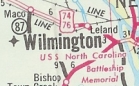
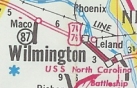
Macon Co.: Nantahala Nat'l Forest Swain Co.: Bryson City Jackson Co.: Sylva Haywood Co.: Waynesboro, Lake Junaluska, Clyde Buncombe Co.: Enka Henderson Co.: Hendersonville Polk Co.: None Rutherford Co.: Forest City Cleveland Co.: Shelby, Kings Mountain Gaston Co.: Gastonia, Belmont Mecklenburg Co.: Charlotte, Matthews Union Co.: Stallings, Monroe, Wingate, Marshville Anson Co.: Polkton, Wadesville Richmond Co.: Rockingham, Hamlet Scotland Co.: Laurinburg Robeson Co.: Maxton Columbus Co.: Chadbourn, Whiteville, Lake Waccamaw, Bolton Brunswick Co.: USS North Carolina Battleship Memorial New Hanover Co.: Wilmington, Wrightsville Beach |
History: |
US 74 was an original US Highway from late 1926. Initially it ran only from Asheville to Chadbourn. Here is a closer look geographically:
Tennessee to Shelby
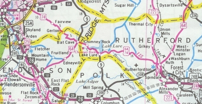
By 1930, US 74 was placed on modern US 74-A through the greater Fairview Area.
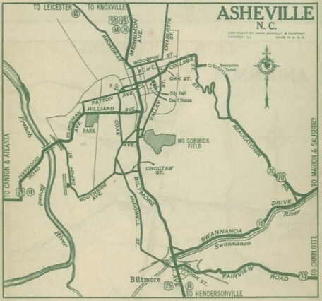
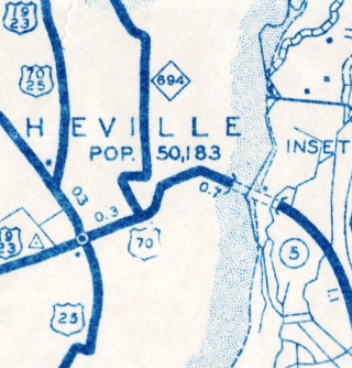
About 1938, US 74 west was truncated to US 70 Tunnel Rd. leaving behind US 70 into Downtown Asheville. Although topo maps show a duplex well into the 1960s, the 1936 Buncombe County is the last NCDOT County map to show US 74 with US 70 into downtown. Maps from 1938 onward do not show a duplex.
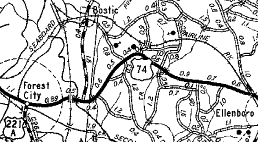
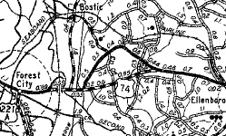
Between 1945-49, US 74 was removed from SR 1595 west of Ellenboro and placed on today's US 74 Business.
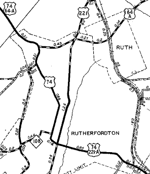
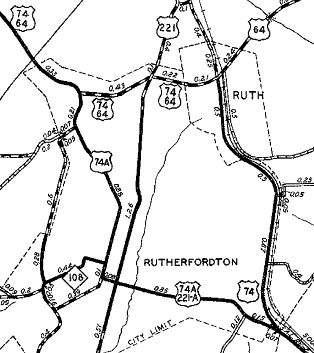
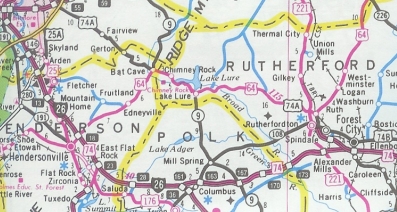
In 1948 or 1949, US 74 was given its first bypass of Rutherfordton, using Railroad Ave north to Ruth and US 64 Mountain Rd westward. The old route through Rutherfordton became US 74-A (now US 74 Business).
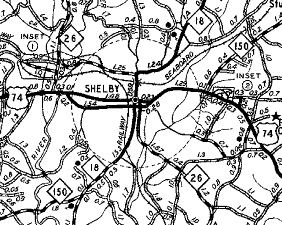
About 1949, US 74 was given its bypass of Shelby, leaving behind US 74-A (now US 74 Business).
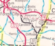
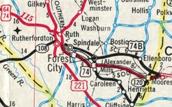
Between 1959-62, US 74 was removed from SRs 2316 and 2319 east of Shelby. On Dec 3, 1970 (NCDOT), US 74 was placed on a new freeway that bypassed Spindale, Forest City, Ellenboro, and Mooresboro, leaving behind an extended US 74 Business from Rutherfordton eastward, except through Mooresboro which became just Main St.
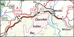
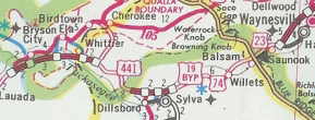
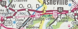
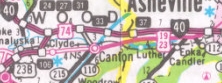
In 1987, US 74 was extended west along US 70 into Downtown Asheville (Tunnel Rd, College Ave, Charlotte St); attached to I-240 across the French Broad River; attached to US 19-23 through West Asheville, Enka, Canton and Lake Junaluska; replaced US 19-A through Waynesville, Sylva, and Bryson City; attahced to US 19 southwest through the Nantahala Gorge, Andrews and Murphy; attached to US 64 west to the Tennessee Line.
In 1994, US 74 was rerouted from Rutherfordton to Asheville by new freeway south of Forest City west to I-26 at Columbus (the freeway from I-26 to NC 108 was built as an unnumbered roadway in 1975, then extended around 1992 to NC 9; also, the freeway from Forest City west to US 221 had also opened as unnumbered routing in 1992). US 74 then followed I-26 to I-40, then west with I-40 to Exit 44 before resuming its routing with US 19-23 through Enka, etc. The old route via Lake Lure and Fairview to Asheville to I-40 Enka became US 74-A.
On Feb 4, 1998 (NCDOT), US 74 was removed from US 19-23 through Canton and Enka. Instead, US 74 was placed on I-40 from Exit 44 west to Exit 27, then replaced SR 1660 on the connector back to US 19-23
US 74 is planned to bypass the Natahala Gorge using NC 28 and passing very near Robbinsville before coming back to present US 19-74-129 at Andrews. Shelby to Wadesboro
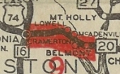
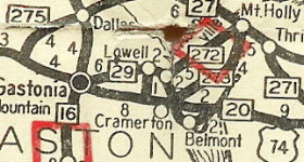
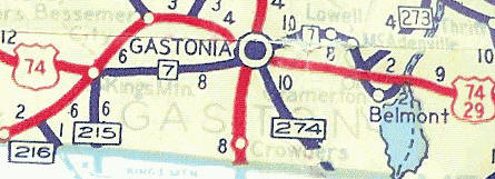
In 1929, US 74 was placed on its modern routing between Gastonia and the Catawba River. The old route became NC 29 (now mostly NC 7).
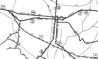
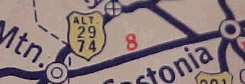
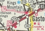
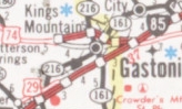
In late 1936, US 74 was rerouted to run directly from Kings Mountain using today's US 74 Business and current US 74 over to Gastonia. This was a replacement for part of NC 7. The old route via Bessemer City became a short lived US 29A-74A.
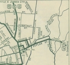
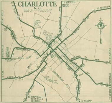
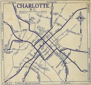
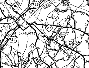
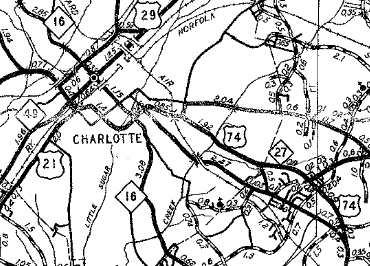
Also around 1936, US 74 was rerouted in Charlotte to stay on Moorehead to McDowell then northeast to 7th. Mint St became non-primary while Trade St remained part of NC 271.
In 1937 or 1938, US 74 was removed from central Wadesboro and put on US 74's current routing.
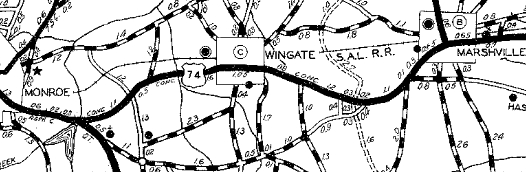
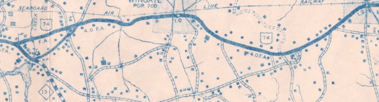
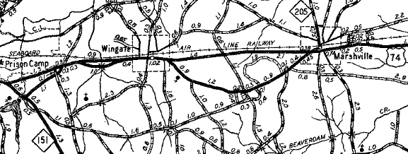
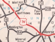
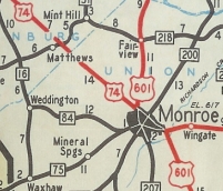
In 1937 or 1938, US 74 was removed from NC 151 (now US 601) and "Old US 74" east of Monroe. Between 1945-49, US 74 was placed on its modern routing through Wingate and Marshville.
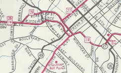
About 1949, US 74 was rerouted in Charlotte and eastward: It left Moorehead at South St (then-US 21) onto a newly constructed Independence Blvd. which threaded its way eastward and ran parallel between 7th and Central, tying back in to original US 74 in the Rama area.
About 1952, US 74 was given its Monroe Bypass, leaving behind US 74-A (unnumbered today). About 1953, US 74 was placed on its current alignment from Rama to the west end of the Monroe Bypass leaving behind SR 1009 Monroe Rd. Between 1955-57, US 74 was rerouted in Western Charlotte to avoid Moorehead altogether (remained part of US 29) and instead used Dowd Rd and more newly built Independence Blvd. In 1983 or 1984, US 74 was placed on its freeway bypass of Kings Mountain, leaving behind US 74 Business and David Baptist Church Rd.
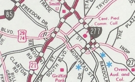
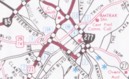
Around 1988 (per Steffora), US 74 was moved from Independence Blvd onto I-277's southwestern part. The first Official map to show this was the 1992-93 Official. The old route is now Wilkinson and Carson Blvds.
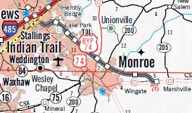
On 11/27/2018 (aaroads post from "Chris"), a new US 74 Bypass (Toll Road) was opened from just east of I-485 to bypass Monroe.
Wadesboro to Chadbourn
By 1930, US 74 used Lee St and Ellerbe St south to modern US 74 Bus. in Rockingham.
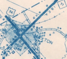
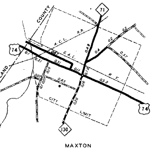
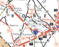
Also between 1939-44, US 74 was straightened out through Maxton.
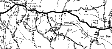
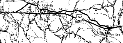
Between 1945-49, US 74 was placed on its modern routing from Wadesboro to the Pee Dee River, bypassing Lilesville and a long old US 74.
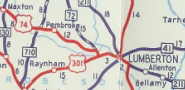
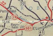
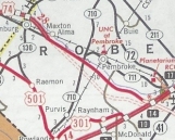
In 1949, US 74 was built o a new alignment to bypass Pembroke and tie in to US 301 further south of Lumberton. The old route was secondary for a couple years but has mostly been NC 711 ever since.
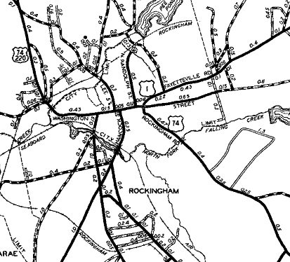
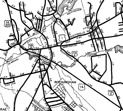
Between 1950-53, US 74 was placed on today's US 74 Business in Rockingham. The old route using Washington/Rockingham Sts. became US 74-A (now not primary except brief bit of US 1).
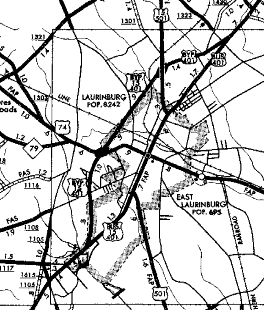
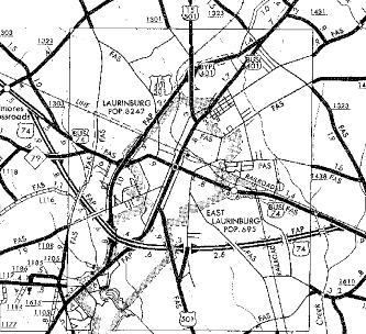
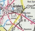
In 1967, US 74 was placed on a new bypass of Laurinburg, leaving behind US 74 Business.
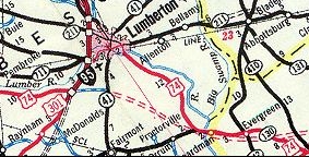
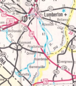
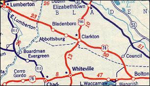
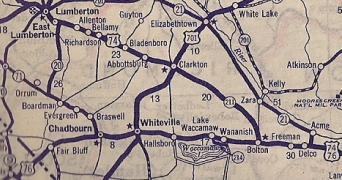
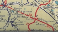
In Feb 1973 (NCDOT), US 74 was placed on new alignment to bypass Lumberton altogether, tying into the old route at the NC 130 junction near Boardman. The old route remained I-95/US 301 plus a little NC 41 through Lumberton, then SR 1620 (now part of NC 72). In Sept 1975 (NCDOT), US 74 was removed from Strawberry Blvd west of Chadbourn, replaced by SR 1574.
In 1985, US 74 was given its freeway bypass of Maxton which tied into the Laurinburg bypass. The old route through town became an extended US 74 Business.
In late 2000 (Steffora), US 74 was placed on a new freeway bypass of Rockingham and Hamlet, leaving behind US 74 Business.
In Oct 2007 (NCDOT), US 74 was placed on newly constructed I-74 from the Maxton Bypass to just east of I-95, leaving behind US 74-A.
Chadbourn to the Atlantic Ocean
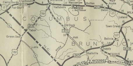
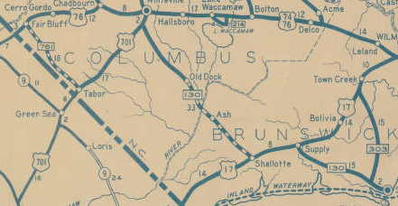
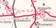
At any rate, US 74 by 1936 definitely returned to running via Chadbourn and concurrent with US 76 eastward along today's US 74-76 Business through Chadbourn and Whiteville. Note that the DeLorme Atlases label SR 1554 west of Whiteville as "Old US 74" but this loop was never US 74.
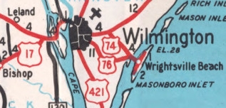
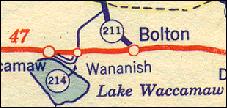
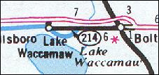
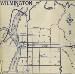
US 74 followed NC 214 through Lake Waccamaw and Bolton, then current US 74-76 to near Leland. At Leland, US 74 used post Office Rd and Lincoln Rd, then Old Mill Rd to Village Rd NE. US 74 followed this to Belville, then used the closed causeway just south of current US 17-74-76 across the Brunswick River. Then US 74 followed today's NC 133 routing north of Belville in a loop to cross the Cape Fear River and the NE Cape Fear River. US 74 then headed south on 3rd St to Market where I think it ended (all maps including '35 official show only US 76 heading out to Wrightsville).
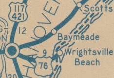
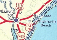
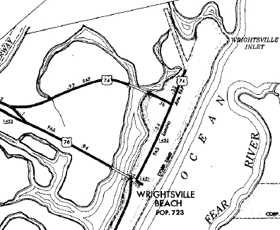
Also in 1936, US 74 was extended along US 76 out to Wrightsville via Market St, 17th St south to current US 76 Oleander Dr, then east until Airlie Rd which it followed to where US 76 crosses onto Wrightsville Beach. US 74 then turned north on Lumina Ave which it followed to its endpoint at Salisbury St. In 1953, US 74 was rerouted in Wilmington to follow US 17 Market St east to what is now Old Eastwood Rd at the US 117/NC 132 jct, then used Old Eastwood and Eastwood Rd to meet US 76 at the Intracostal Waterway bridge. The old route to Wrightsville remained part of US 76.
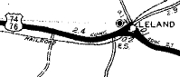
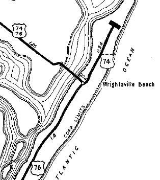
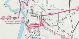
In 1955, US 74 was given its own bridge to Wrightsville Beach, leaving behind some US 76 and secondary Lumina Rd. US 74 was then extended northeast up Lumina to end at Parmele Blvd. In 1969, US 74 was rerouted to enter Wilmington on a new bridge directly from Belville to downtown Wilmington. EB US 74 then used Dawson St and 17th St to Market St. WB used 16th St and Wooster St. 16th and 17th had been part of US 76 but the rest was new primary routing. The old route became US 421 north, then NC 133 across the Cape Fear and NE Cape Fear Rivers. 3rd St and Market St out to 16th became unnumbered for a while. In Sept 1975 (NCDOT), US 74 was placed on new freeway to bypass Leland and Belville leaving behind SR 1472 in the Leland area and SRs 1484 and 1485 in Belville.
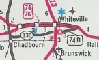
Also in Sept 1975 (NCDOT), US 74 was placed on its freeway bypass of Chadbourn, and returned to today's 74-76 Business via SR 1435 Union Valley Rd (designated officially as TEMPORARY US 74-76). The old route through Chadbourn remained part of NC 130 and is now also US 74 Business. Shortly after, US 74 was added to the new freeway bypass of Whiteville, leaving behind US 74 Business.
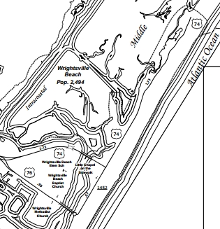
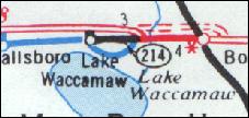
In 1986 or 1987, US 74 was put on a bypass of Hallsboro and Lake Waccamaw, leaving behind a little rerouted NC 214 and SR 1757 that later became NC 214. In March 1989 (NCDOT), US 74 east was extended 1.46 miles over SR 1888 from Parmele Blvd to its current endpoint at the end of Lumina.
About 1992, US 74 was given its bypass of Bolton, leaving behind an extended NC 214.
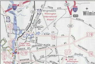
About 1997, US 74 was removed from today's Old Eastwood Rd. In Dec 2005 (NCDOT), US 74 was removed from downtown Wilmington and instead followed NC 133 across the Cape Fear River, then new freeway east to 23rd, then replaced existing SR 2649 along Martin Luther King Jr Parkway to where it connects with Eastwood Rd at US 17. The old route remained part of US 17 (now US 17 Business)
|
Comments: |
US 74 is a major thoroughfare across the southern border of North Carolina.
US 74 is nearly 100% multilane and is full freeway in many places. The concurrence with an identical numbered interstate is a first for America. This could have been avoided by renumbering US 74 as US 72. |