All U.S. Highways | Home
|
All U.S. Highways | Home |
| U.S. 21 118 miles | ||||||
| The Road: | Enters Mecklenburg County from South Carolina. Crosses into Virginia
from Alleghany County.
Nationally, U.S. 21 runs from Hunting Island, S.C. to Wytheville, Virginia, but used to run all the way to Cleveland. |
|||||
| Towns and Attractions: | Mecklenburg Co.: Charlotte (I-77;
Sunset Road; Statesville Road); Huntersville
Iredell Co.: Statesville (Shelton Avenue; Center Avenue; Davie Street) Wilkes Co.: Climbs the Blue Ridge at Bucks Peak. Crosses ECD at Roaring Gap (elevation approx. 2400; about a low as the ECD gets in the state). Crosses BRP at milepost 229. Allegany Co.: Sparta (Main Street) |
|||||
| Multilane Segments: | Four lanes or more through Statesville. Four lanes divided for a few miles north of I-77 exit 83. Brief hilliclimb lanes northbound up Bucks Peak. Multiple lanes (naturally) where co-signed with I-77. | |||||
| History: |
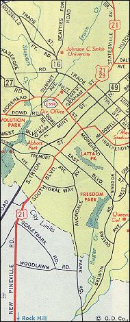
Substantial parts of 21 were rerouted over Interstate 77 once that Interstate was opened. First, around 1965, a mostly-freeway bypass was built east of Jonesville and Elkin. The entire bypass became part of U.S. 21, leading to the creation of Business 21 through Elkin. The southernmost four miles of this bypass would eventually become I-77 from exit 79 to 83. In 1969, 77 was opened between exits 28 and 33, along 21's prior alignment. Also around 1969, the southernmost few miles of I-77 in the state were completed, from the state line probably to Woodlawn Road in Charlotte. At this time 21 was signed over the Interstate, and U.S. 521 was extended northward over 21's old South Boulevard alignment. Note that north of Woodlawn(?), U.S. 21 would continue to be signed over Charlotte surface streets for several years. Around 1975, when 77 was entirely completed through Charlotte, 21 was routed over the Interstate all the way north to Sunset Road (exit 16). Today, 21 jogs along a short stretch of Sunset between the Interstate and Statesville Road. The streets over which 21 had been routed went unnumbered. |
|||||
| Comments: | The Jonesville/Elkin bypass has one diamond interchange (with C.C.
Camp Road) north of I-77, and north of that, several at-grade crossings
before the four-lane stretch ends. Exit 83 is a partial interchange; the
only access is from northbound 77 to northbound 21, and from southbound
21 onto southbound 21/77. Also, exit 83 is a left exit for U.S. 21 northbound.
The hillclimb up the Blue Ridge has been straightened out over the years, and parts of the original alignment are still visible. This short stretch is a tad twisty, and because of the intermittent hillclimb lane, wide-open, but there's nothing too exciting here. Evidence exists of 21's original Charlotte routing: one eating establishment on South Boulevard is still called the South 21 Drive-In. |
|||||
| Ideas: | Just for fun, put U.S. 21 back along South Boulevard and route it through
downtown Charlotte again.
For real, re-sign 21 all the way north to Cleveland; to hell with Ohio 21 and 821 and W.V. County 21. |
|||||
| Business U.S. 21 8 miles | |
| The Road: | Through Jonesville, Yadkin County, and Elkin, Surry County.
Bypassed in 1965 or 1966. Part of this bypass now exists as exits 79 to 83 of I-77. |
| U.S. 121 dead | |
| Formerly: | Ran from Lexington north to Winston-Salem and
Mount Airy; continued further north to U.S. 11 in Virginia. Not a preliminary
1925-26 U.S. highway, but apparently lasted from 1927 to about 1933 or
maybe '34.
U.S. 121 was signed entirely over the original N.C. 66. Some earlier maps, however, have 121's southern terminus in W-S, not Lexington. By 1935, 121 was superseded by U.S. 52, a much longer road in the state and in the nation. |
Previous: U.S. 220 | Next: U.S. 221
| All U.S. Highways
Top | NCRoads.com
Home
![]()