| N.C.
50 169 miles |
|
|
|
|
| The Road: |
|
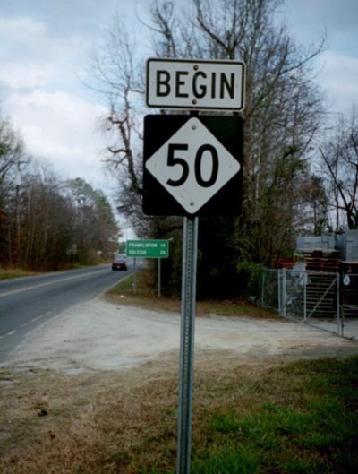
Begins at US 15/NC 56 Creedmoor (Granville County) and ends at the south end of the island at Topsail Beach (Pender County).
|
Towns and Attractions: |
|
Granville Co.: Creedmoor
Wake Co.: Raleigh, Garner
Johnston Co.: Benson
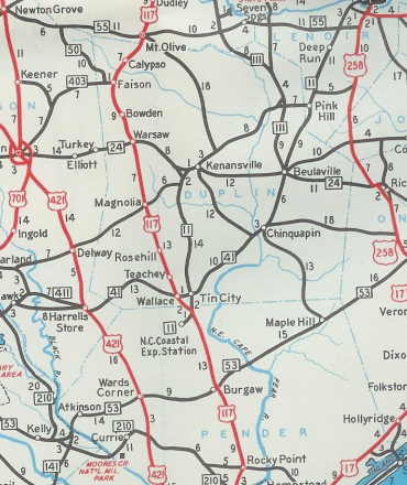
Sampson Co.: Newton Grove
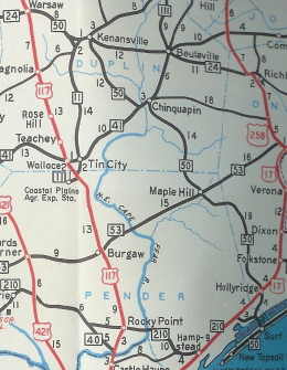
Duplin Co.: Faison, Warsaw, Kenansville
Pender Co.: None
Onslow Co.: Holly Ridge
Pender Co.: Surf City, Topsail Beach
|
History: |
|
NC 50 was born in 1935 as a renumbering of the brief NC 221, running from NC 55 Coats east to Benson, then southeast to NC 55-102 (now just NC 55) west of Newton Grove.
In 1937, NC 50 was replaced by NC 40 from Coats to Benson, and instead routed north from Benson as new primary routing to end at US 70 (now just W. Garner Rd) Garner.
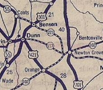
NC 221 Coats to Newton Grove
1934 Rand McN
|
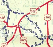
NC 50 appears, Coats to Newton Grove
1936 Official
|
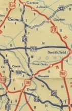
NC 50 rerouted Benson to Garner
1938 Official
|
In 1952, NC 50 was extended with NC 55 through Newton Grove to Dobbersville, then southeast as new primary routing to end at either NC 403 or US 117 in Faison.
In 1953, NC 50 north was truncated to the new US 70 bypass of Garner.
Between 1956-58, NC 50 was extended along US 117 to Warsaw, cut a small corner as new routing to NC 24, followed NC 24 east to Kenansville, then used new primary routing southeast to the beach, with short duplexes with NC 41 and NC 210.
NC 50 extended to Faison; no primary route from Kenansville to Topsail Beach
1950 Official
|
NC 50 extended out to the coast
1958 Official
|
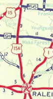
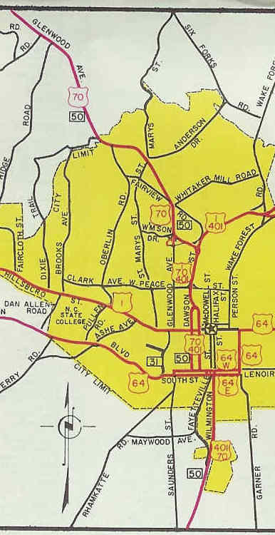
In 1957, NC 50 was extended along US 70 through Raleigh, then replaced US 15-A from Raleigh north to Creedmoor, including the small piece of Wilton Ave between US 15 and Main St. In Raleigh, NC 50 used Wilmington St north to Lenoir St which it followed west to a one-way split using Dawson (SB) and McDowell (NB), then just Dawson St (now part of Capital Blvd) to Williamson Dr where NC 50 cut west to Glenwood which it rode out of town.
US 15-A Raleigh to Creedmoor
1936 Official
|
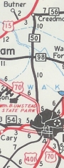
NC 50 replaces US 15-A north of Raleigh
1958 Official
|
In 1967 or 1968, NC 50's Raleigh routing changed slightly with the extension southward of the one-way split to include S. Salisbury St from South St to S. Wilmington St
In 1973 or 1974, NC 50 was removed from Glenwood northwest of Raleigh and instead was placed with US 401 northeast on Capital Blvd out to the Raleigh Beltway which was just US 1-64 at the time. NC 50 (with US 70 all this time) followed the freeway west back to Glenwood.
NC 50 initial Raleigh offering
1958 Official
|
NC 50 after changes in the late 60s and early 70s
1974-75 Official
|
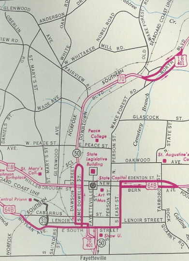
In 1983 or 1984, NC 50 (with US 70-401) was taken off Raleigh streets within the now-completed Beltline. NC 50 cut from S. Wilmington St onto Saunders Ave to the Beltline, then followed it east and around to the north side of the city to connect back up with NC 50 at Capital Blvd, continuing as before on the Beltline to Glenwood.
NC 50 was restored to Raleigh streets between 1991-93.
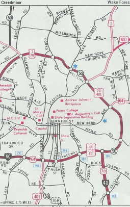
NC 50 totally on Beltline
1990-91 Official
|
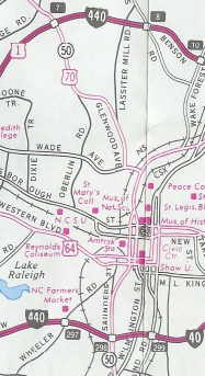
NC 50 restored to Raleigh thoroughfares
1993-94 Official
|
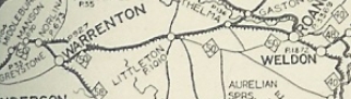
The first NC 50 was an original state highway. In 1921 it ran from NC 40 (probably Weldon Rd) Roanoke Rapids west to Warrenton via US 158, Old Macon Hwy and US 158 Business; US 1 and US 1 Business to Norlina and Henderson. NC 50 then turned south on tody's US 1 Bus; US 1 and the two current US 1-A's through Franklinville and Wake Forest. NC 50 followed US 1 down to Old Wake Forest Rd and Wake Forest Rd into Raleigh. From there NC 50 followed Person St south to Edenton St, then west through the Capitol Square and west on Hillsborough St. to Cary. NC 50 followed Chatham St through Cary, then Old Apex Rd to Apex. NC 50 used Salem St through Apex, and followed "Old US 1" all the way down to US 15-501 to Sanford. NC 50 used US 1 Business through Sanford, but used Carthage St down to Tramway. NC 50 used US 1-15-501 to the route split, then followed Rocky Fork Church Rd. NC 50 followed US 1 and US 1 Business through Vass. NC 50 used Valley View Rd through Niagara which used to connect via RR bridge to Clark St through Manley and then Broad St through Southern Pines. NC 50 may have used Poplar St through Aberdeen. NC 50 used US 1 down to Hoffman, then McDonald Church Rd southwest to US 1 into Rockingham and South Carolina . NC 50 continued as SC 50 on its way to Columbia, SC.
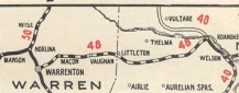
In 1922, NC 50 from Norlina to Roanoke Rapids was renumbered as NC 48. Instead, NC 50 turned north to Virginia to meet the new VA 122 heading for South Hill. NC 50 used today's US 1 to do this except it used Hyco St out of Norlina and the Mac Powell Rd loop near I-85.
NC 50 Norlina to Roanoke Rapids
1922 Auto Trails
|
NC 50 re-routed to Virginia
1924 Official
|
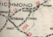
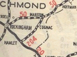
In 1925, NC 50 was removed from McDonald Church Rd at Hoffman. Instead it replaced NC 204 to Marston, then cut west as new routing on today's US 1 to Rockingham.
NC 50 on McDonald Church Rd<
1924 Official
|
NC 50 replaces some of NC 204
1925 Official
|
As best as I can tell, the only other change to NC 50 before it was abandoned for US 1 in late 1934 was that south of Tramway it was removed from Rocky Fork Curch Rd and put on today's US 1. This looks to have occurred about 1933.
|
Comments: |
|
NC 50 used to be signed from I-95 as a way to Raleigh before I-40 came along.
NC 50 cuts through some sparse territory east of Kenansville to the beach.
With little traffic in the eastern half and close proximity to I-40 elsewhere, prospects seem dim for route improvements south of Raleigh.
NC 50 does still run on Wilton Ave with NC 56 between US 15 and Main St.
|